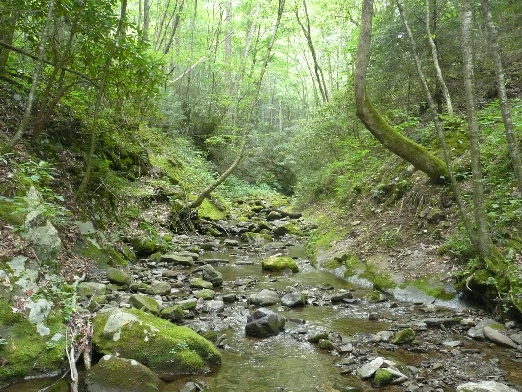
Clarks CreekClarks Creek Recreation Area is located in the hollows and draws of Cherokee National Forest's Bald Mountain Zone. Dense forest blocks out much of the sun and sky keeping the area well shaded, while the many streams flowing into Clarks Creek keeps the area lush and green.
Several trails veer off from Clarks Creek's main artery, Forestry Road 25. The longest trail is the Long Arm Branch Trail while the most popular is the hike to Sill Branch Falls. Many of the trails are built from the remains of old forestry roads. These old roads don't always end when the trail does. Upon first crossing the bridge entering into Clarks Creek, directly to the left is the remains of the old Clarksville Iron Furnace built in 1833 by Montgomery Stuart, Edward West, and Elijah Embree. The furnace was supplied by the mines located on other side of Embreeville Mountain in Bumpus Cove. The Embrees were strong Abolitionists in this area of Tennessee. Besides hiking, Clarks Creek is a popular place to fish and horseback ride. Clark's Creek is more primitive in the amenities than other areas such as Rock Creek or Horse Creek. Clarks Creek does not have facilities such as toilets or picnic tables. Designated camp spots are interspersed in Clarks Creek along Forestry Road 25. None of the camping spots have hookups. The hikes described below are: Sill Branch North Trail, Sill Branch South Trail, Pine Ridge Falls starting from Longarm Branch Trailhead, and Longarm Branch Trail. |
Clarks Creek

Clarksville Iron Furnace built in 1833
|

|
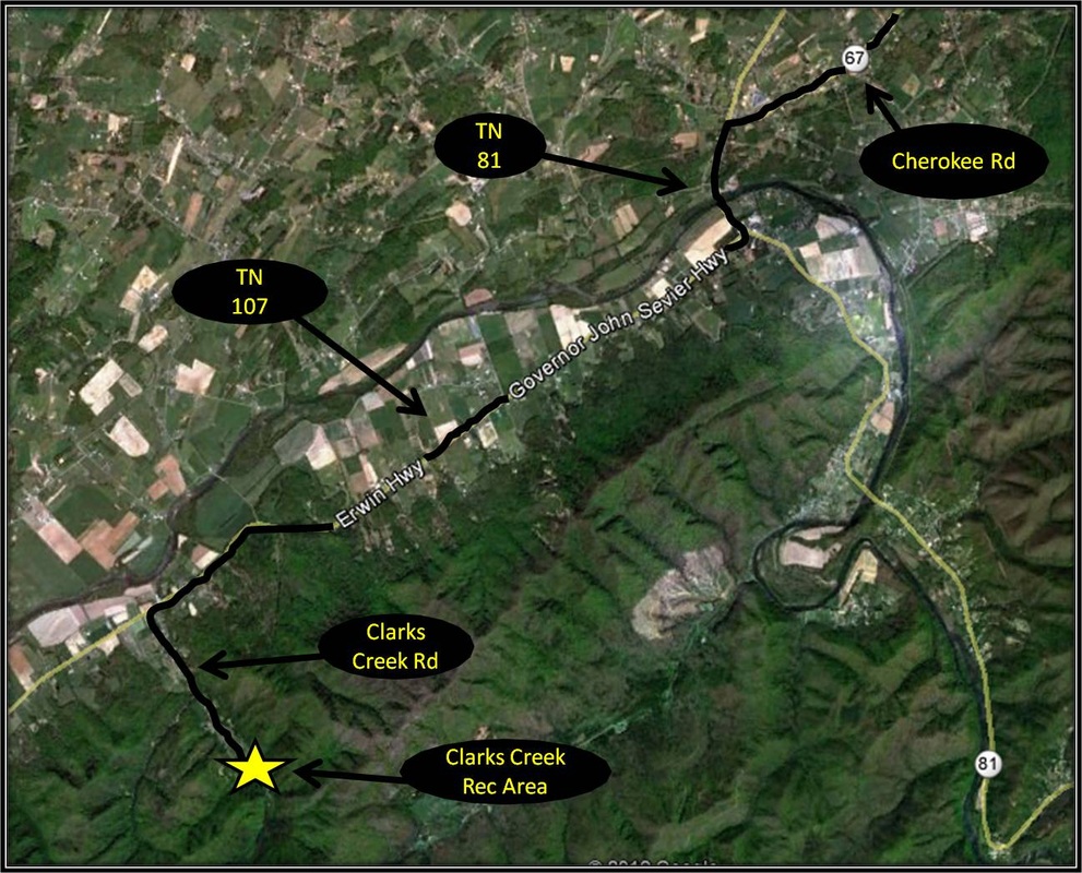
Driving Directions:To get to Clarks Creek Recreation Area from ETSU, follow West Lake Street as the road becomes Southwest Avenue. Make a right on Cherokee Road, also known as Highway 67. Follow Cherokee Road until the road ends and then make a left onto Highway 81 in the direction of Erwin. Take a right on Highway 107 headed toward Greeneville not long after crossing the Nolichucky River. Stay on Highway 107 until making a left on Clarks Creek Road. Keep on Clarks Creek Road which will eventually become a forestry road as Clarks Creek Recreational Area is reached. The road is bumpy but well maintained. Driving Directions to Clarks Creek using Google Maps is linked here. |
Sill Branch North Trail (to the Falls)
|
Distance: 1 mile round trip
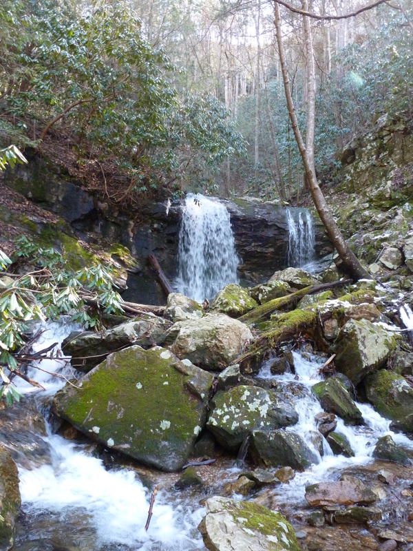
Situated in a secluded cove, Sill Branch Falls is just 20 feet in height but they are beautiful and provide a serene setting to relax after a brief uphill jaunt along the well maintained Sill Branch North Trail. The trek to the falls is one mile round trip. Beneath the dense forest cover, side trails occasionally split away from the main path and lead to attractive points along Sill Branch Creek. Glow worms inhabit the rocky cliffs around the falls and at night the cliffs flicker with tiny flashes of light. The verdant splendor of this particular piece of Cherokee National Forest, in addition to its short and easily navigated trail makes Sill Branch Falls a popular destination but there are a few points to consider before hiking the trail. The trailhead is located to the left 1.7 miles after crossing the first bridge into Clark's Creek. A series of large rocks form a boundary to separate the parking area from the trail. The trail to and from the falls is approximately one mile in length. The hike to the falls is all uphill, most of it is reasonable but there are some steep parts. The trail divides into two paths not far from the falls. Stay to the left along the Sill Branch North Trail in order to see the falls. There is a stream crossing shortly after the trail splits but well-positioned rocks make it possible to keep your shoes dry. After crossing the stream, the trail makes a steep ascent before leveling out and quickly leading to the base of the falls. The way back is all downhill, just be careful of loose rock that can make footing tricky. While the waterfall feels a million miles from anywhere, it is located in the Clark's Creek Recreational Area in Cherokee National Forest just 25 miles from the ETSU main campus (I previously published information on this hike for the East Tennessean in an article linked here). Further Online Resources: Greeneville Hiking Club (Recommend) Cherokee National Forest Link (Current as of Spring 2024) |

Sill Branch Falls
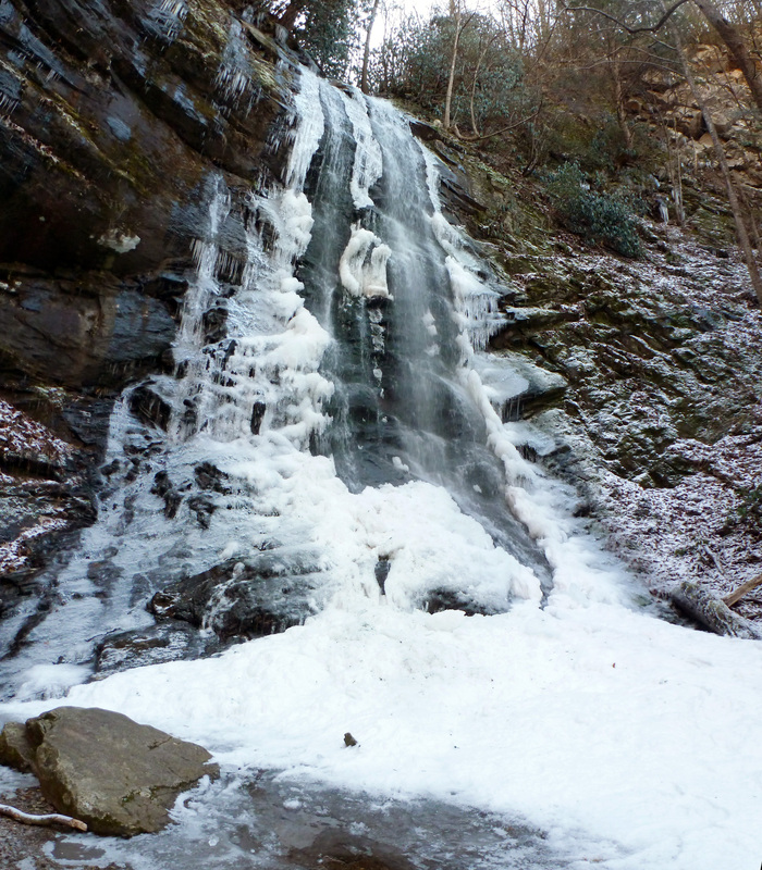
Sill Branch Falls
|
Sill Branch South Trail
|
Distance: Approximately 3 miles round trip
The Sill Branch South Trail is an excellent spring wildflower hike. Trillium, a variety of Violets, Wild Irises, Foamflowers, Gaywings, and Frasier's Sedge bloom in volumes along the moderately steep but steady path following the south fork of Sill Branch to its infancy before petering out about 1.5 miles from the hike's start point. The Sill Branch South Trail starts from the same location as the hike to Sill Branch Falls and for a short distance the two trails are the same, splitting near where the two forks of Sill Branch merge. The Sill Branch South Trail forks right and the path turns more steep for a short stint, but levels out as the rock formations on the right are passed and the trail turns left. From here the path is mostly reasonable uphill until reaching the last little bit before the turn-around. There are eight (8) points where the trail crosses the stream for a total of 16 creek crossings. On most occasions these crossings can be accomplished without getting wet by rock hopping. Toward the end of the hike, the path will turn right and journey up a very steep hill, so steep its easy to believe this is not the trail but a possible dry stream bed or run-off. A blue blaze located further up will confirm the identity of Sill Branch South Trail. The trail only climbs a bit further before the creek peters out. Showy Orchids grow on the hillside above the far banks of the stream, to the right of the trail. From here the trail veers left and shortly after dissipates into the forest. This is a there and back again hike so the way back is pretty much all downhill. Sill Branch South Trail is a short, easy-to-navigate trail at an approximate round trip distance of 3 miles, but the trek does have some steep moments along the way. Further Online Resources: Appalachian Treks RATtreks (Current as of Spring 2013) |
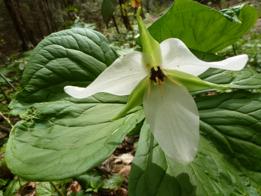
Trillium growing along Sill Branch South Trail
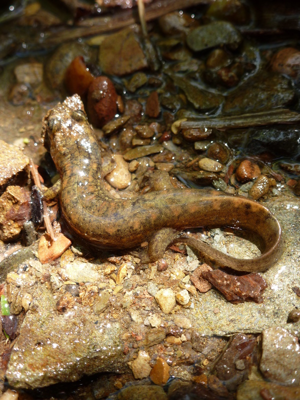
Salamander along Sill Branch South Trail
|
Pine Ridge Falls
Distance: Approximately 1 mile round trip
The hike to Pine Ridge Falls is a short but rather pleasant stroll through dense forest. The trek begins at the trailhead for Longarm Branch Trail located aproximately 0.2 miles further down past the trailhead for Sill Branch Falls. From the trailhead, follow the Longarm Branch Trail until just after crossing a stream. Here the trail forks with Longarm Branch Trail continuing right. The path to Pine Ridge Falls is to the left leading up a hill that eventually opens up into a cove and Pine Ridge Falls. This is a there and back again hike approximately one mile in length round trip. Because of the shortness of the hike, many also do the hike to Sill Branch Falls in the same day. (Current as of Summer 2014) |
Pine Ridge Falls
|
Longarm Branch Trail:
|
Distance: Approximately 7.2 miles total, 3.6 miles one-way
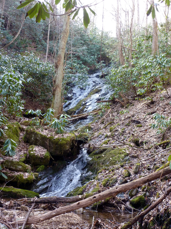
The Longarm Branch Trail is maybe best known as the starting point to the short hike to Pine Ridge Falls, or as a part of a potential route to get to Chigger Ridge's distant vantage of the reputed Buckeye Falls. On its own merit, Longarm Branch Trail is a formidable trail leading 3.6 miles up to Bearwallow Gap on Rich Mountain. At Bearwallow Gap is an intersection of Longarm Branch Trail, Forest Road 190 and a side-trail leading briefly down to Lower Higgins Creek Trail. For much of the hike, Longarm Branch Trail follows Longarm Branch crossing the creek at four points, most likely these points can be crossed without getting wet by rock-hopping. During wetter days, the trail can become a part of seasonal streams / run-offs. As a popular trail for horseback riding, the trail can get a bit mushy when it is muddy. Shortly after the first creek crossing is where a side-trail splits left leading to Pine Ridge Falls. Veer right following Longarm Branch. Yellow Blazes mark the trail's route. From here the trail often gets steep and at times the footing can be aggravatingly rocky. While a bit obscured by the trees, Upper Longarm Branch Falls is just above the 4th point where Longarm Branch is crossed. Like many of the other falls in the area, the Upper Longarm Branch Falls are tied to the weather and can look pretty thirsty during dry times. The trail sharply and steeply turns left after the 4th crossing, paralleling the falls and continuing upward through dense rhododendron thickets. As the rhododendron thickets give way to mixed forest, the trail levels out into a brief shady valley. In the valley, the trail passes through a backcountry campsite with a fire ring. At the campsite, Longarm Branch Trail makes a sharp left crossing over a drainage pipe leading away from Longarm Branch along the hillside. Yellow Blazes mark the way but are not clearly visible where the trail splits. The backcountry campsite is at a fork and a trail also continues straight, leading up and over a berm following Longarm Branch up a draw in Rich Mountain. This is the route taken to cut off some distance to Chigger Ridge and the vantages of Chigger Branch Falls. The sharp left turn is the toughest navigation moment on Longarm Branch Trail and it is easy to miss the turn and continue straight. After veering left, Longarm Branch Trail switchbacks up the hillside, steadily leading up to Bearwallow Gap. There are two more moments where the trail forks. In both instances veer right. Yellow Blazes mark the path and fallen branches have been laid to block the wrong turn. Not far past the second fork, Bearwallow Gap is reached. Bearwallow Gap is an opening in the forest and a crossroads where FS190 intersects with Longarm Branch Trail, a gated side-trail leading down to Lower Higgins Creek Trail, and an older vanishing forest road. Once at Bearwallow Gap, the way back is 3.6 miles making for a total hike of 7.2 miles. The way is well-marked with a yellow blaze but there are few spots where navigation can be tricky. The lower half of the hike can be very rocky and offers the steeper moments of the journey. The difficulty level for this hike is of moderate to difficult do to the uphill and distance. Longarm Branch Trailhead is located about 1.9 miles from where Forest Road 25 crosses the 1st bridge into Clarks Creek. Further information on Longarm Branch Trail as a gateway to viewing Buckeye Falls is linked below. I highly recommend reading RATtreks on Clarks Creek and the Rocky Fork. There are very good details on navigating the Longarm Branch and Lower Higgins Valley. Further Online Resources: RATTreks: Longarm Branch Trail to Chigger Ridge RATTreks: Longarm and Wilderness Falls Greeneville Hiking Club: Sill Branch Long Arm Loop (Current as of Winter 2014) |

Along Longarm Branch Trail
Upper Longarm Branch Falls

Along Longarm Branch Trail
|
