Buffalo Mountain Park
|
Obtained from the National Forest Service, Buffalo Mountain Park is 725 acres primarily designed for hiking and picnicking. Buffalo Mountain has many short trails that connect to one another. Among the most popular destinations for these hikes are Tip Top, the White Rocks Overlook, and High Knob.
Tip Top is the highest point of Buffalo Mountain within the park but the views even in winter are obscured by forest. Still, there is something to be said for reaching the top. White Rocks offers views of Interstate 26 and the mountains to the east. High Knob overlooks Johnson City with views of the downtown, the Mountain Home, and the top of the Mini-dome. The views from either High Knob or White Rocks on a snowy day are quite incredible. The trailhead for the White Rocks Overlook begins near the bottom of the park, just a little past the turn-off onto an access road that leads to the antennas situated on top of Buffalo Mountain. The access road is on the left, when the hard surface road makes a sharp right headed up the mountain to where the picnic area and main trailhead for the park is located. However the main trailhead for White Rocks Overlook is located at the base of the park, no more than 30 yards from the turn-off from the hard surface road. In total the hike to White Rocks Overlook is a little over 2 miles round trip. The trail initially follows a stream headed toward Hartsell Hollow. The stream is crossed twice by bridge before reaching a tree with a double white blaze sprayed onto it. A sign has also been hammered into the tree’s left side. From this tree, the trail to white rocks heads left up the mountain. This turn can be tricky and a lot of hikers find their way to the end of the Hartsell Hollow Trail before they realize they have missed their turn. After turning left, the trail gets steeper as the route climbs through dense hardwood and rhododendrons. With fallen leaves covering the trail, the way can be difficult to spot at times so keep an eye out for white blazes that mark the path. The trail will eventually level out as a clearing created by overhead power lines is reached. From here the trail crosses the access road that leads up to the antennas. A small stream is easily crossed as the trail heads back into dense forest. From here the trail levels out and becomes a bit friendlier than the uphill just completed, however the route is still up hill with some steep stretches. The good news is that none of these steep stretches are all that long. There are several vantage points from the White Rocks Overlook. The last of the views is not far from the antenna complex. The way back is almost all downhill. Further Online Resources: Johnson City Parks & Rec Site Buffalo Mountain Park Hiking Trails Map TEHCC: Buffalo Mountain Park (Current as of Spring 2013) |
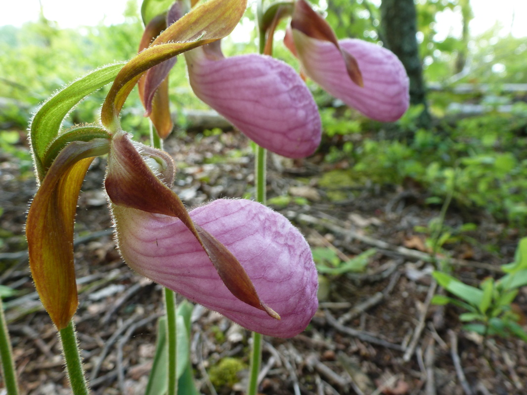
Pink Lady Slippers

Mountain Laurels
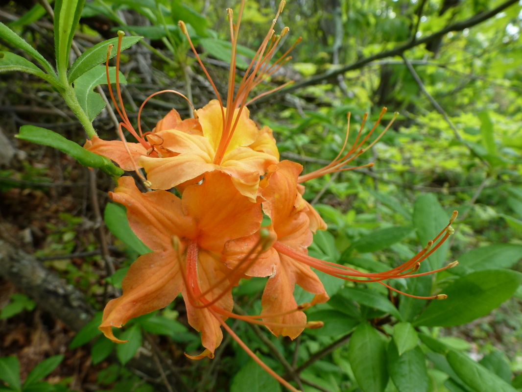
Flame Azalea
|

|
Driving Directions:
To get to the trailhead from ETSU, from West Lake Street take a left onto Southwest Avenue, and merge right onto University Parkway. From University Parkway, turn right on Cherokee Street. Shortly after turning onto Cherokee Street, turn left onto Buffalo Road. From Buffalo Road, turn right onto Rolling Hills Road and from Rolling Hills Road turn right onto Highridge Road. Highridge Road leads directly into Buffalo Mountain Park.
Buffalo Mountain is a great place to hike in all seasons and is home to many different species of wildflowers to include the Mountain Laurel and the Pink Lady Slipper Orchid. Despite being a city park, the trails are alive with wildlife and a hiker is just as likely to run across rattlesnakes, wild turkeys, bears, or white-tailed deer as in the back-country. Driving Directions to Buffalo Mountain Park using Google Maps is linked here. |
Pinnacle Tower Trail
|
Distance: 9.6 miles round trip
Standing upon the highest point in Washington County, Pinnacle Tower was originally built by the Civilian Conservation Corp over 70 years ago with the purpose of keeping a lookout for fires. The tower served this purpose until 1989 and has since been reborn with a new vision for drawing in tourists and outdoor enthusiasts with its beautiful panoramic views. Pinnacle Tower Trail was built in conjunction with the reopening of Pinnacle Tower and begins from Jack Snider Park (and in the future the Tanasi Heritage Center) in the town of Unicoi. The trail is well-made with long switchbacks that minimize steep uphill climbs. Pinnacle Trail does lead to the top of Pinnacle Mountain so it is impossible to negate the ascent, but all the uphill climbs are quite reasonable. There are no stream crossings that threaten getting shoes soaked. Additionally, the trail is well marked with green blazes. There are no tough land navigation moments, with maybe the exception of crossing the gravel road about 3.2 miles into the hike. A trail sign and a green blaze do mark the trail, just in case there is any confusion with the multi-use trail leading from Dry Creek Road. The multi-use trail leads off to the right and uphill, where Pinnacle Tower Trail leads straight and into a draw of the mountain before switching back along the hillside and up toward the hilltop where Pinnacle Tower awaits with some beautiful views. Despite the beautiful views from the tower, most of the 9.6 mile trek is through forest, whether along hillside or in the draws. Under the canopy and along the trail, an impressive amount of wildflowers bloom throughout Spring, including Mountain Laurel, Mountain Stonecrop, Flame Azalea, and Pink lady Slippers. Pinnacle Trail is a there and back again hike of moderate difficulty do to the distance of the hike. Further Online Resources: TEHCC: Pinnacle Tower Trail Appalachian Treks Hiking Bill (Current as of Spring 2013) |

Pink Lady Slippers Blooming Along Pinnacle Tower Trail
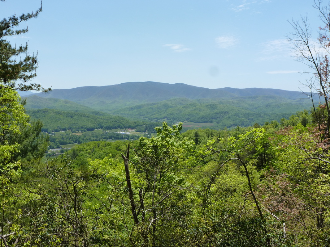
View from Pinnacle Tower Trail
Flame Azalea along Pinnacle Tower Trail
|
|
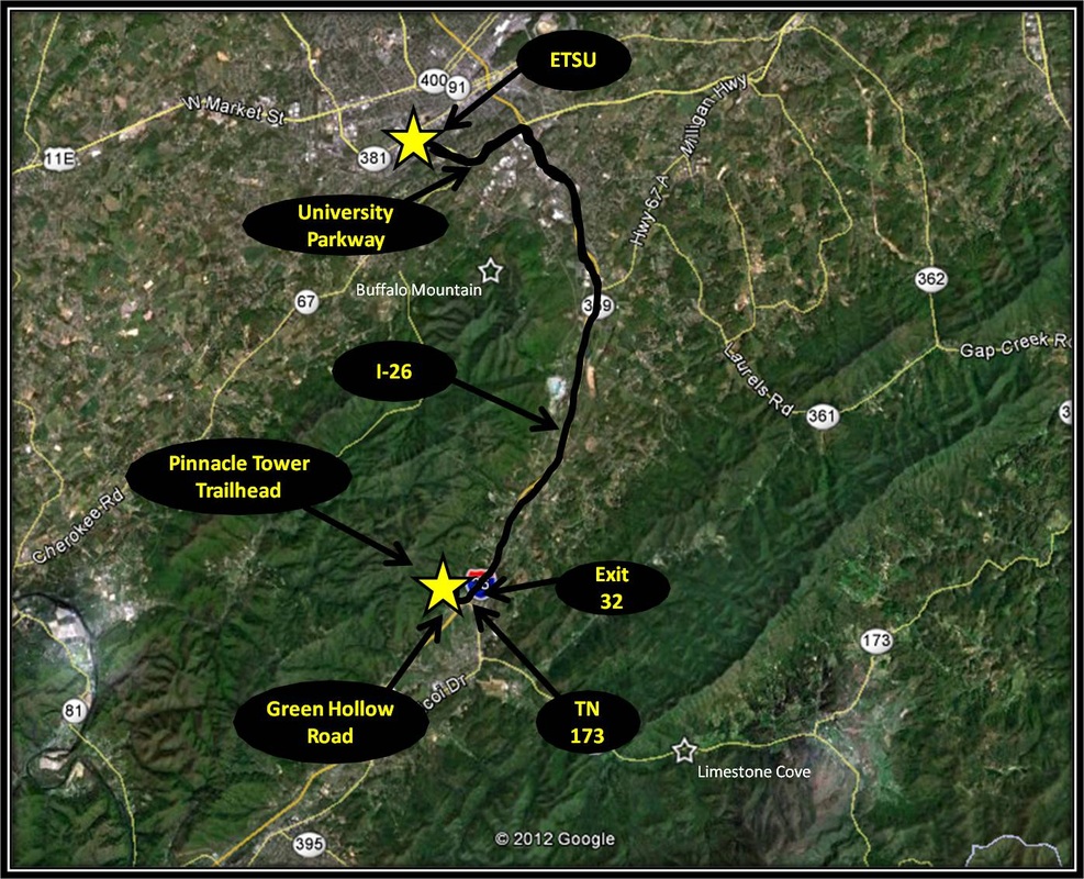
Driving Directions:
From ETSU, turn right onto University Parkway headed toward Elizabethton. Turn right onto I-26 headed toward Erwin. Take Exit 32 for TN-173. Take a right onto TN-173 from the exit ramp.
Shortly after making a right onto TN-173, you will come to a three-way stop with Jack Snyder Park being directly across the road. There is still a lot of construction being done on the park and in the future a heritage center is also being built. There is some parking available in the park, but people also use the sides of Green Oak Road to park. Driving Directions to the Pinnacle Tower Trailhead using Google Maps is linked here. |
