Camp Creek Bald and Surrounding Area
|
This section describes day hikes located near to Camp Creek Bald. Among the hikes listed close to Camp Creek Bald are: the Appalachian Trail (AT), Margarette Falls, Bullen Hollow, Philips Hollow, and Greene Mountain Trail. Cherokee National Forest recognizes this area as being a part of the Bald Mountain Zone. The Bald Mountain Zone includes Clarks Creek, Horse Creek, Old Forge, and Round Knob. Details of these places and their walks are located elsewhere on this site.
The hikes described below are: Margarette Falls Trail, Jones Meadow to Firescald Knob along the AT, & Chimney Rocks Trail. |

View of Camp Creek Bald from Blackstaff Cliffs
|
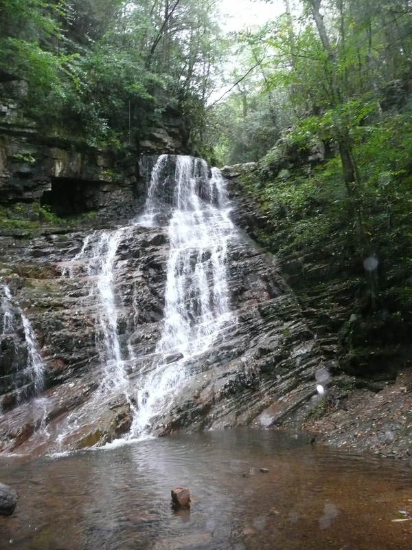
Margarette Falls
Distance: 2.5 miles round trip
Nestled in a draw on Green Mountain near the community of Camp Creek, Margarette Falls is one of the taller and more beautiful waterfalls in the region and with just a round-trip distance of approximately 2.5 miles. Margarette Falls is also one of the easier paths to hike. The hike begins on a fairly level, closed forestry road surrounded by dense growth of rhododendrons. In warmer months, wildflowers grow along the trail but they are now mostly gone along with the autumn foliage. After hiking for approximately half a mile, the trail splits. The way that goes left almost immediately requires crossing Dry Creek and leads to the Philip Hollow Trail. Stay right to remain on the trail to Margarette Falls. About 15 feet from the first fork in the trail, the trail forks again. The path to the right is the point where Bullen Hollow Trail diverges from the Margarette Falls Trail, so veer left and follow the path that more closely follows Dry Creek. After splitting from the Bullen Hollow Trail, the trek becomes steeper and the difficulty of the walk gets tough. Despite the added steepness, the beauty of the trail only increases because of the route Dry Creek is carving on the way to level ground. The path provides many views of the different cascades and chutes formed by the creek. On the way up to the falls, rocky cliffs tower over the left side of the creek. In the past year, there have been a lot of improvements to the trail. Previously the trail crossed Dry Creek several times and the creek crossings often made the trail confusing to follow. As the path follows the creek to the base of the falls, simply sticking to the creek easily solves losing track of the trail. This is no longer a problem. Now the trail crosses the creek only twice and the first crossing is by a recently constructed bridge. The second creek crossing can be accomplished without getting wet by hopping rocks. The trail has also been more clearly marked by spray-painted, blue rectangle blazes making navigation even easier. This information is taken from an article I wrote for the East Tennessean. That article is linked here. Further Online Resources: Greeneville Hiking Club Link (Recommend) Cherokee National Forest Link (Current as of Spring 2013) |
Margarette Falls

Margarette Falls in the vigor of early Spring
|
|
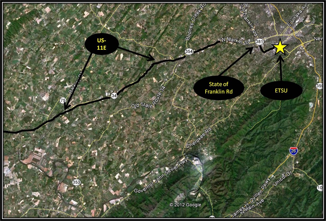
Driving Directions:
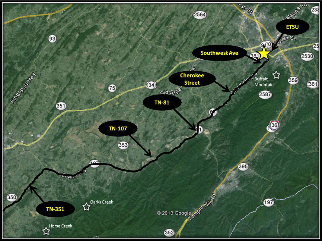
To get there from ETSU, follow State of Franklin Road until turning left onto US-11E. Stay on US-11E for about 23 miles before making a left onto Highway TN-107 headed toward Erwin.
Turn right onto TN-351 just after crossing the Nolichucky River and follow TN-351 for 5 miles until reaching a 4-way stop. Turn left onto Greystone Road. Stay on Greystone Road for 4 miles before making a right onto Shelton Mission Road. The large parking area for the trail is on the right after traveling 1.3 miles on Shelton Mission Road. Once on TN-107, there are plenty of signs pointing the way to Margarette Falls. Directions to the start point for Margarette Falls using Google Maps is linked here: Margarette Falls Start Point |
Jones Meadow to Firescald Ridge along the AT
|
Distance: 4.5 miles round trip loop hike
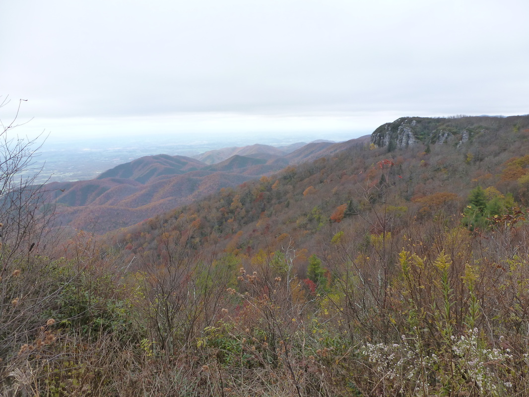
The trek over Firescald Ridge from Jones Meadow along the Appalachian Trail offers some of the best 360 degree panoramas in the region. In addition to the views, as Spring turns to Summer, Catawba Rhododendron, Bluebead Lilies, Speckled Wood Lilies, Turkeybeard, Red Chokecherry, & many other wildflowers bloom along the AT through this section. In Fall, the many lookouts give full display to the leaves changing from green to red and gold. The hike begins from Jones Meadow. Jones Meadow is already on top of the ridgeline and there are no long ascents to see the views offered by Firescald Ridge, Blackstaff Cliffs, or Jones Meadow. There is some uphill and some downhill but for the most part the trail feels mostly level, or maybe reasonable is better way to describe the route. The difficulty of this 4.5 mile trek is from the uneven, rocky footing along the AT as the trail crosses over Firescald Ridge. The exposed trail over the ridge also involves some rock scrambling and some minor climbing. If ankles are a concern, than this trail screams for boots with good support. From Jones Meadow, follow the road down the steep hillside and back up a steep hillside for a brief stint before connecting to the AT. Not long after linking up with the AT headed northbound, a side-trail leads to the awesome views offered by Blackstaff Cliffs. The rhododendrons are pretty dense along this side trail. After returning to the AT from Blackstaff Cliffs, continue northbound passing by Jerry's Trail which links up to the AT on the right. A few steps more and the split in the AT is reached. A sign marks the split. Veer right following the exposed trail over Firescald Ridge. From here the footing gets tougher, only easing up as the turn-around point is reached but the views are well worth it. Not far past crossing over Firescald Ridge the bad weather trail and the exposed trail merge. A sign marks where the trails merge/diverge. From here follow the bad weather trail back. The bad weather trail begins as a steady uphill before becoming a steady downhill on the way back, linking back up with the AT. From here it is a short jaunt back along the AT to Jones Meadow the start point of the hike, passing by Jerry's Trail and the side-trail of Blackstaff Cliffs. At only 4.5 miles, this hike is of moderate difficulty because of the rocky footing and rock scrambling involved. I learned about this loop hike online from the Greeneville Hiking Club. I highly recommend the intel they provide on this hike, including their excellent map linked below. Greeneville Hiking Club and the Carolina Mountain Club are made up of hiking enthusiasts/volunteers who maintain the AT through this section. Their thoughtfulness and hard-work on the AT has created an awesome experience for countless dayhikers and through-hikers. Beside the AT, Greeneville Hiking Club is also a major player in the maintenance of the many other trails located in Greene County. Further Online Resources: Greeneville Hiking Club Greeneville Hiking Club: Relocation Loop Carolina Mountain Club: AT Mileage |
View of Blackstaff Cliffs from Jones Meadow along the AT
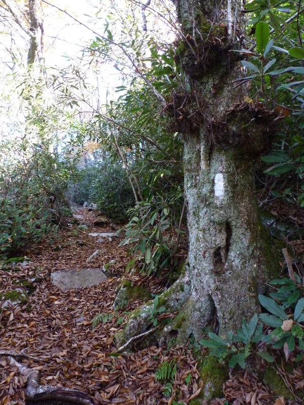
The White Blaze marks the Way along the AT

View from Firescald Ridge
|
|
Driving Directions:
From ETSU, follow Southwest Ave until the stop sign and turn right onto Cherokee St. Follow Cherokee St until it comes to an end at a stop sign and make a left onto TN-81.
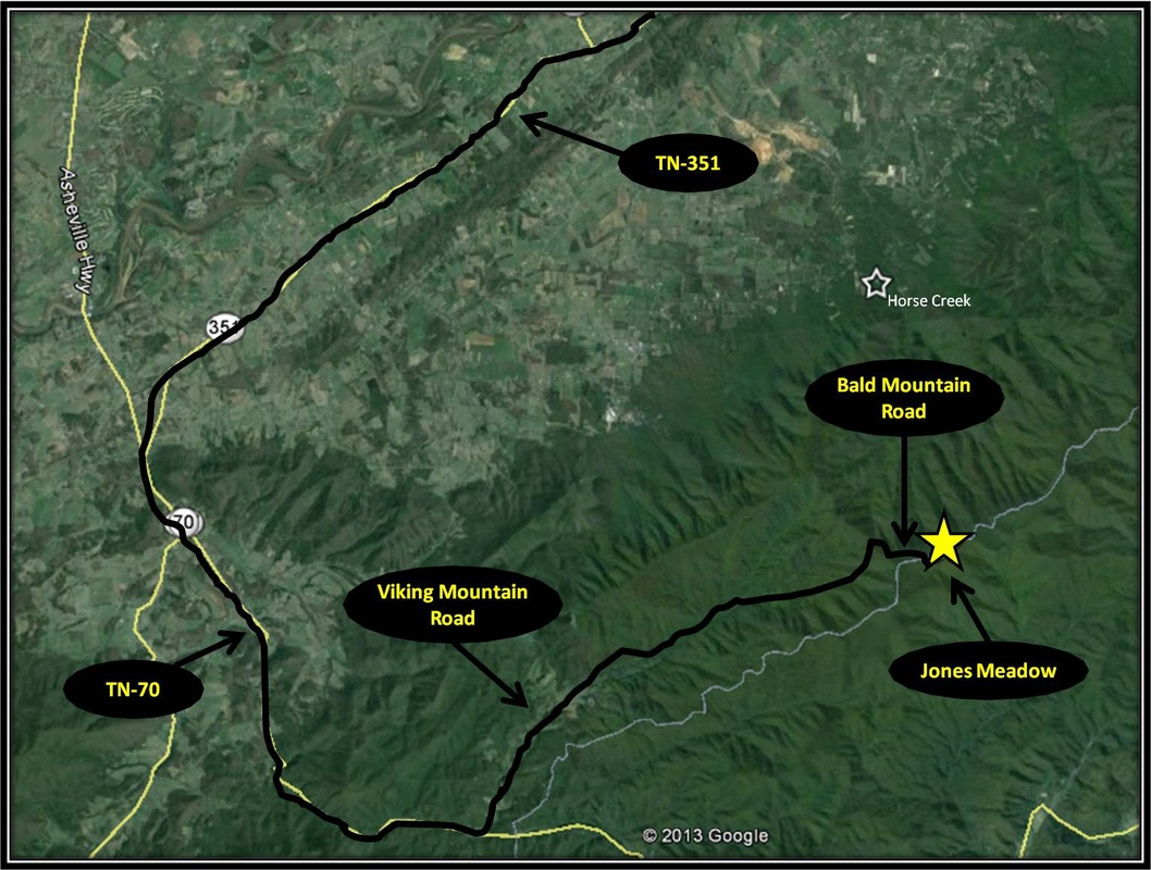
Shortly after crossing over the Nolichucky River on TN-81, turn right onto TN-107 for about 16 miles. At a stop light, turn left from TN-107 onto TN-351. Stay on TN-351 for 11.3 miles and then make a left onto TN-70, aka the old Asheville Highway. Follow TN-70 for 6.6 miles, then turn left onto Viking Mountain Road. Follow Viking Mountain Road as it winds up from the valley toward Camp Creek Bald. Eventually Viking Mountain Road becomes Bald Mountain Road not far from where the road spits out onto Jones Meadow. On top of the ridgline, the road comes to a three-way intersection. Take the road headed left and park, the start point has been reached. Be wary of taking the road all the way to big dirt parking area if you are driving a low clearance vehicle. There are hidden and cringe-worthy bumps as the road descends into the area. Viking Mountain Road does turn into a forest road headed up the hillside but it is a well-maintained and well-traveled road. Signs mark the way. Directions to the start point for the hike from Jones Meadows using Google Maps is linked here. |
