Paint Mountain & The French Broad River
|
This section covers Paint Mountain, the Paint Creek Corridor, Meadowbrook Mountain, and the French Broad River. The hikes described below are Chimney Rocks Trail to the Overlook and Wolf Creek Falls Trail.
Further Online Resources: Cherokee National Forest: French Broad River Zone Cherokee National Forest: French Broad River BCHET: Greene & Cocke Counties Trails |
Wolf Creek Falls
|
Chimney Rocks Trail to the Overlook
|
Distance: 4.4 miles total, 2.2 one way
Along Chimney Rocks Trail starting from Weaver's Bend, the sandy soil simmers under the summer sun as the scent of hot pine & border bramble accents the way to an opening with a vista of a valley forged by the French Broad River with Round Mountain's silhouette set in the background. Chimney Rocks Trail's start point is located on Forest Road 209 (FS-209), within eyesight of where the railroad crosses both FS-209 & the French Broad River on the Lower Twin Bridge. A road gate and two trail signs with conflicting distances mark the hike's beginning. The trail begins as an old forest road winding up & around a hill through an open field before entering into forest. Not long after entering the forest, the trail cuts through an open field closely paralleling the treeline on the right. Yellow Blazes mark the way, as well as tire grooves. Wild Garlic, Ruellia, & Wild Carrot are a few of the species that bloom in the field during summer. After crossing the field, the trail travels a short distance through forest before coming to a fork in the trail. Head right headed up a series of short switchbacks. A trail sign marks the fork. The deadly Poison Hemlock grows close to the split. Chimney Rocks Trail is fairly wide through the switchbacks but narrows to a single-file path as it cuts back into the forest. From here, the way is through forest in the act of re-creation do to previous fires. Charred tree limbs remain as clues along the trail. Through the forest the path is well cut into the earth which makes the route for the most part easy to follow but during summer, the trail can become obscured by the vegetation's race for the sun's embrace. Also on the upper portions of the trail some of the yellow blazes are fading. From its start point, Chimney Rocks Trail has basically been paralleling the bend in the French Broad as the trail climbs up Paint Mountain. At points the trail can get steep but the uphill is mostly reasonable, eventually cresting & following a fairly level ridge-line. Views of the river, valley, and mountains open up through the trees, but camera shots are mostly screened by foliage. Wild Bergamot, Whorled Coreopsis, & Wild Potato grow on the upper portions of the hike. Not far past the trail leveling out on the ridge, the path begins to climb, coming to an intersection about 2.2 miles from the start of the hike. A wooden trail sign marks the way back down Chimney Rock Trail at the intersection. The forest opens up to Chimney Rock Trail's vista at the intersection. Turn left heading up the hill for a few steps to get a better perspective of the vista of the French Broad River basin. The view is beautiful enough to make the cover of the comprehensive Cherokee National Forest Hiking Guide. From here, Chimney Rocks Trail continues for under a half-mile to its conclusion at Paint Mountain Trail. The right turn headed down the mountain at the intersection is where Paint Rock Trail connects with Chimney Rocks. The vista at the intersection is the turn-around point for the described hike. As a there and back again hike the total distance is approximately 4.4 miles. The hike is of moderate difficulty do to the uphill and vegetation encroaching on the trail. The Greeneville Hiking Club and others incorporate Chimney Rock Trail and Paint Mountain Trail to make an approximate 6.5 mile loop hike. Further Online Resources: Greeneville Hiking Club: Chimney Rocks - Paint Mountain Loop Changing Views of French Broad Valley Highlight of Cherokee Trail by Morgan Simmons (Knox News) (Current as of Summer 2014) |
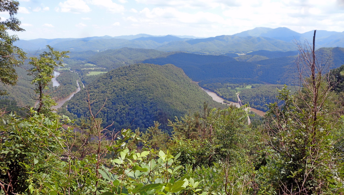
View of the French Broad River from Chimney Rock Trail

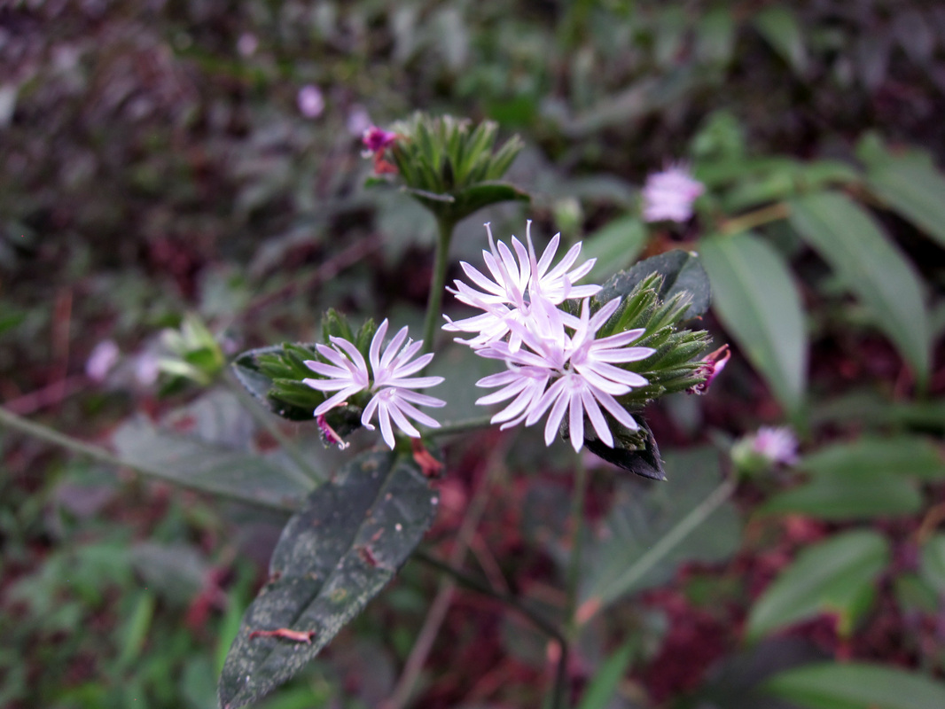
Goats Rue
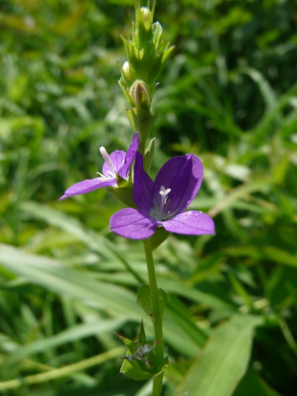
Venus Looking Glass

View of French Broad River from Chimney Rock Trail
|
|
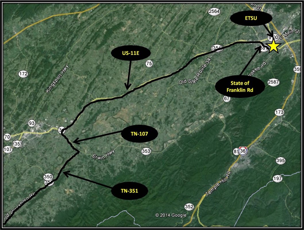
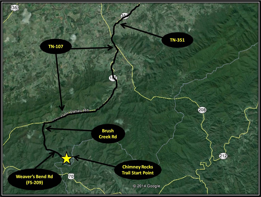
Driving Directions:
Starting from ETSU, turn left onto State of Franklin Rd. From State of Franklin Rd, turn left onto US-11E. Stay on US-11E for about 23 miles before making a left onto TN-107. Stay on TN-107 for 2.7 miles, then turn right onto TN-351 for 11 miles.
Turn left onto TN-107 for about a mile before turning right to stay on TN-107 as it splits from TN-70. After turning right, stay on TN-107 for another 8.7 miles before turning left onto Brush Creek Rd. A forest sign marks the turn. Follow Brush Creek for 3.5 miles where it comes to split in the road. Turn left crossing a single lane bridge onto Weaver Bend Rd. From here the road becomes a well-maintained forest road but be careful of the dips & bumps. Chimney Rock Trail's start point is located about 2 miles from the turn. Parking for the trail is located about 0.1 miles before the start point. A sign marks parking and direction to the trail-head. Driving directions using Google Maps for Chimney Rocks Trail is linked here. |
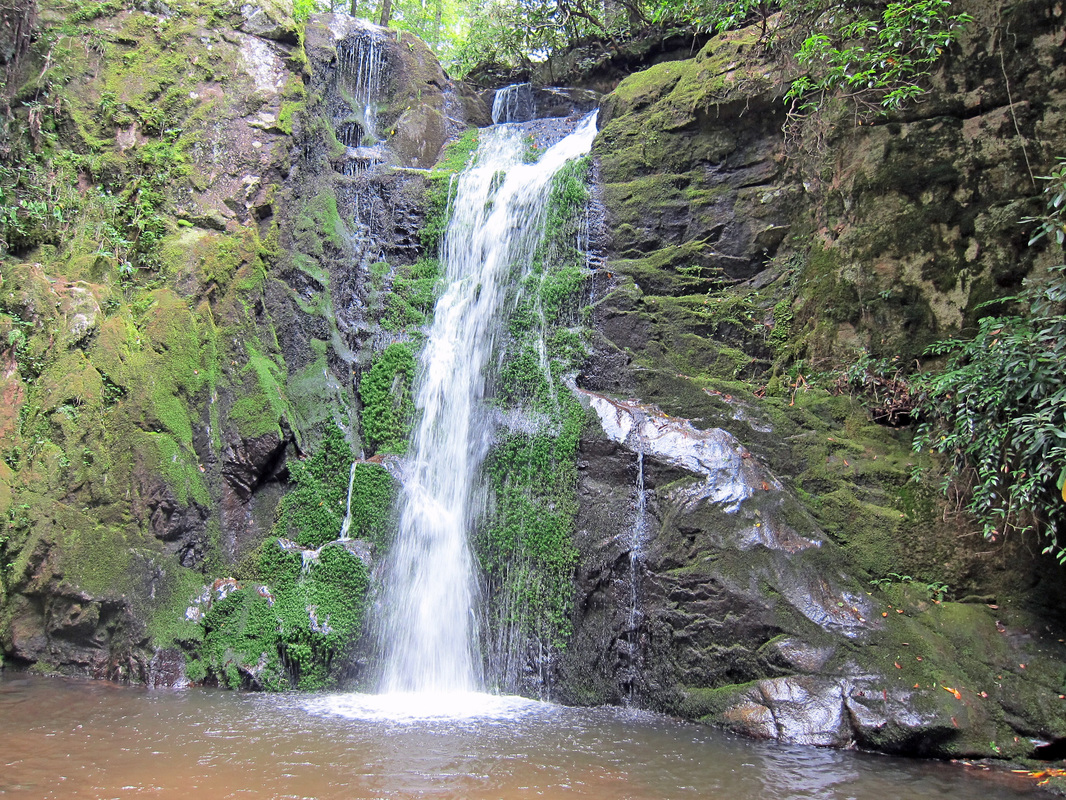
Wolf Creek Trail to Wolf Creek Falls
|
Distance: Approximate 6.2 miles total, 3.1 miles one-way
For the most part, the area of Northeast Tennessee covered by this site is absent mighty & majestic waterfalls like those found in North Carolina's Dupont State Park or Tennessee's Fall Creek Falls State Park. Like many of the nearby falls, Wolf Creek Falls at 30 ft in height is smaller and more intimate, but no less beautiful. The hike to Wolf Creek Falls byway of Wolf Creek Trail is approximately 3.1 miles one-way. Most of the hike is fairly level following Wolf Creek through valley. Dog Hobble and Great Rhododendron are plentiful along the route. Many other wildflowers, like Leafy Elephant's Ear, Wild Phlox, & Spotted Touch-Me-Not also bloom on the trail's edges. There are four different points along the trail where Wolf Creek is crossed. After a good rain or when the water is running high expect to get shoes and socks wet. During dry times, the creek can be rock-hopped. After the 4th crossing of Wolf Creek, the trail gets very rocky for a short distance. The uphill also becomes more noticeable, getting steep as the trail switches away from the creek, climbing up the hillside, before curving back & paralleling Wolf Creek's direction again. After a slight descent, the trail spits out onto a larger forestry road. Turn right at the intersection toward the sound of Wolf Creek. Shortly after turning right, the forest road ends in an open space created by the road's turn-around. A rock fire-ring has been constructed near the center of the open space. Past the open space, side trails lead down to Wolf Creek. The middle side-trail leads to the top of the falls, while a narrow side-trail on the right leads down to the base of the nearby falls. During mid-to-late Summer, Crimson Bee Balm blooms on the boulders near the fall's pool. After enjoying the falls, the way back is the way you came making for an approximate total distance hiked at 6.2 miles. Distance is based on information gathered from Appalachian Treks and GoSmokies.com linked below. Besides the four points where Wolf Creek is crossed, small, often seasonal side-streams intersect the path on several occasions. Sometimes these side-streams share the trail's course. These can be negotiated without any worries. However, Wolf Creek is riddled with mud-holes throughout the hike, many of them quite large and quite mucky. Wolf Creek Trail is primarily a horse trail, looked after by the Back Country Horsemen of East Tennessee (BCHET), but is accessible to hikers and bicyclists. While fairly straight-forward, the route is not marked by painted blaze or trail sign. Given this, the mud-holes, the creek-crossings and the short stretch of steep uphill before reaching the falls, the hike is of moderate difficulty. Further Online Resources: GoSmokies: Wolf Creek Falls Hike BCHET: Greene & Cocke Counties Trails Appalachian Treks: Wolf Creek Falls RATTreks: Wolf Creek Falls (Current as of Summer 2014) |

Wolf Creek Falls
Leafy Elephant's Foot blooming along Wolf Creek Trail
Wolf Creek Trail is primarily a Horse Trail

Many kinds of frogs enjoy the lush environment of Wolf Creek
|

|
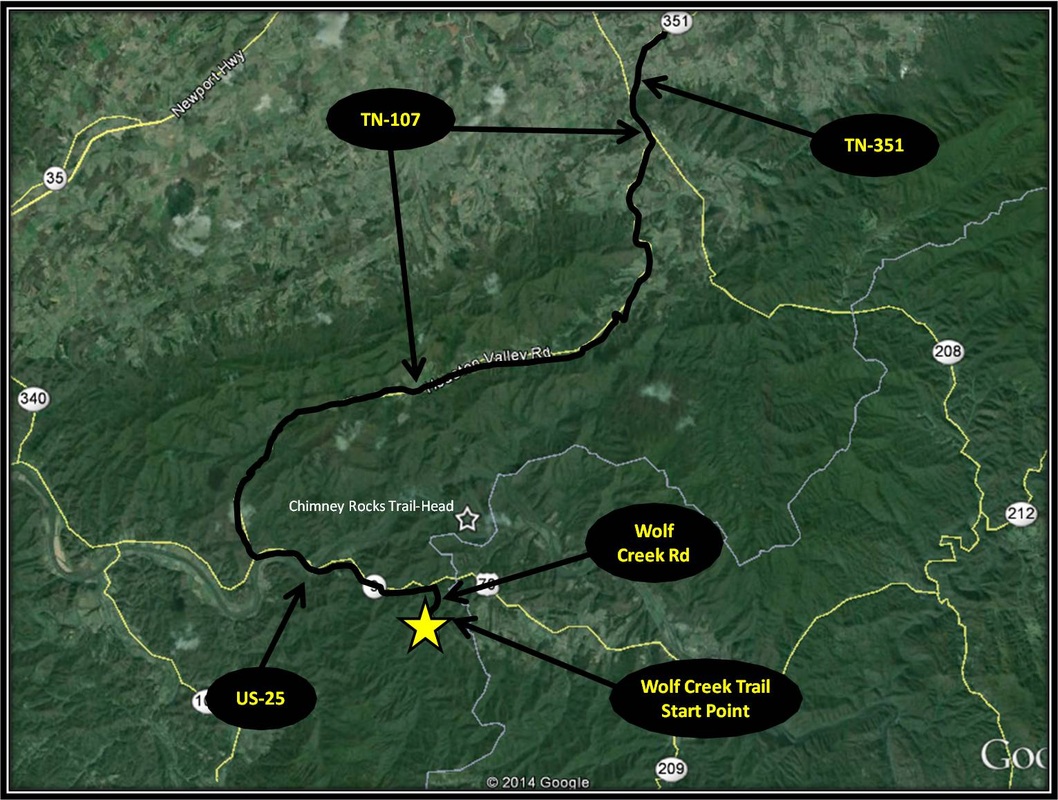
Driving Directions:
Starting from ETSU, turn left onto State of Franklin Rd. From State of Franklin Rd, turn left onto US-11E. Stay on US-11E for about 23 miles before making a left onto TN-107. Stay on TN-107 for 2.7 miles, then turn right onto TN-351 for 11 miles.
Turn left onto TN-107 for about a mile before turning right to stay on TN-107 as it splits from TN-70. Continue on TN-107 for 13.5 miles before coming to a stop sign. Turn left onto US-25. Stay on US-25 for 3.8 miles and then make a right onto Wolf Creek Rd. A sign notating Wolf Creek Trail marks the turn, but a street sign at the turn is absent. About 0.2 miles after turning right onto Wolf Creek Rd, turn right and follow the signs to Wolf Creek Trail for another 0.6 miles. A large gravel parking area will be on the left. There is another spilt before reaching the parking area, with the way right headed up and the way left headed down. A trail signs notates to head left. The last 0.6 miles is rough with many potholes, but manageable for a sedan if taken carefully. The trail starts at the fence with the large 'Pack it In, Pack it Out' sign. Driving directions to Wolf Creek Trail's start point using Google Maps is linked here. |
