Twisting Falls aka Poga FallsDistance: Exact Distance unknown but approximately less than a mile round trip.
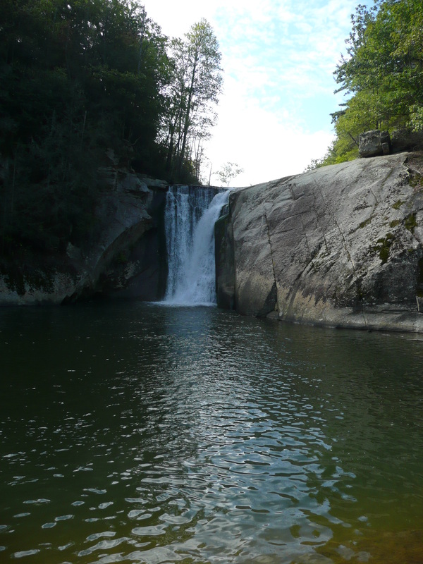
Situated in a remote part of Carter County, Twisting Falls is one of the most powerful and most beautiful waterfalls in Northeast Tennessee. Twisting Falls is also known as Poga Falls, Twisted Falls or Compression Falls and in warmer months, Carolina rose, wild blackberry, and dwarf crested irises bloom along the route to the falls. In the summer, the mist blowing from the powerful waterfall is a welcome relief from the summer heat and swimming is possible at the base of the falls. A rope to the right of the falls leads to the top where people have been known to jump or slide from. Most do so safely but some do not. Rescue takes hours for those injured because of the falls' remoteness and the toughness in getting down to the falls. While Twisting Falls is very beautiful, the short trek to Twisting Falls is among the area's least pleasant hikes and is not recommended when the weather is wet. The trailhead is near a tree marked with yellow and red spray paint, across the gravel road from a barn. At first, the trail is nice as the path leads down through forest into a clearing where power lines cross over. Once in the clearing the path turns left and abruptly heads down the hill. From here the journey to Twisting Falls is less a hike and more like falling down a well-traveled and dangerously steep run-off. Head left after reaching the Elk River at the bottom of the steep descent. A portion of the falls is easily spotted following the Elk River but full views of the falls cannot be experienced without climbing over some very slick rocks or by swimming the river. Be careful as the rocks are always slick from the spray coming off the falls. After enjoying the falls, the way back is ruthlessly steep. Further Online Resources: Appalachian Treks: Twisting Falls RATtreks: Twisting Falls Waterfall Picture Guide: Twisting Falls (Current as of Spring 2011) |

Partial View of Twisting Falls
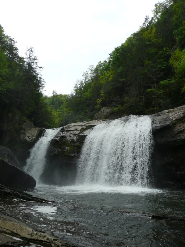
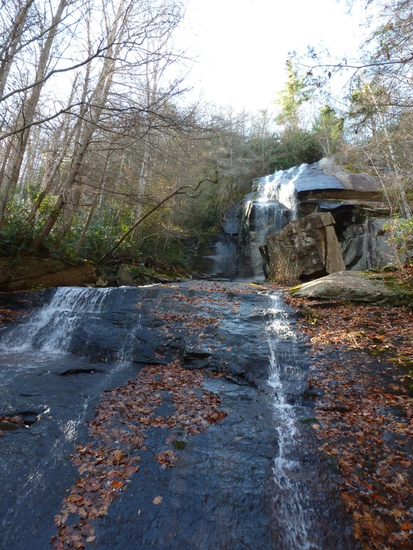
Twisting Falls
|
|
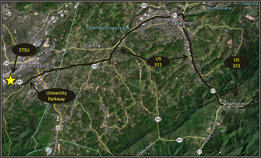
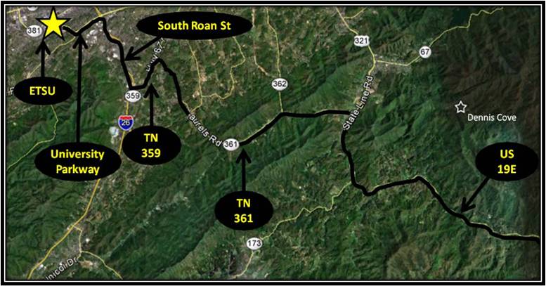
Directions:To get to the trailhead from ETSU, from West Lake Street take a left onto Southwest Avenue, and merge right onto University Parkway also known as U.S. Highway 321. Continue on 321 to Elizabethton. Stay on 321 while traveling through Elizabethton. Turn right in the direction of Hampton at the intersection where Highway 321 merges with U.S. Highway 19. Continue on 321 to Hampton.
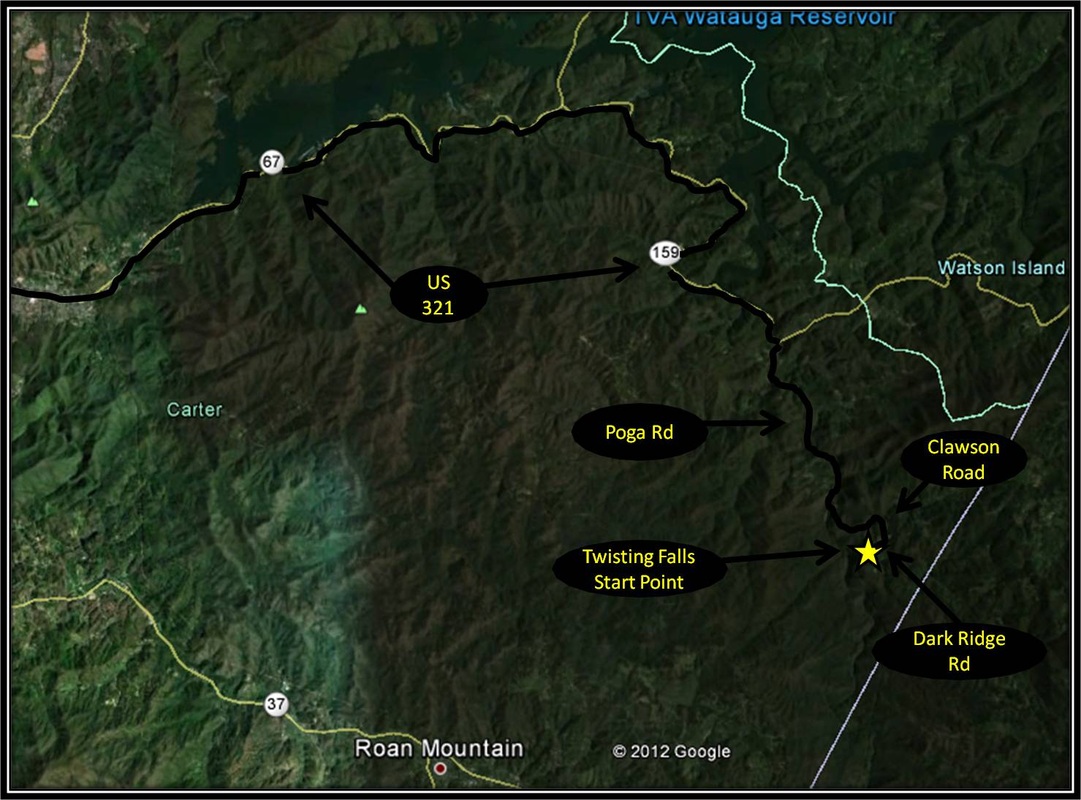
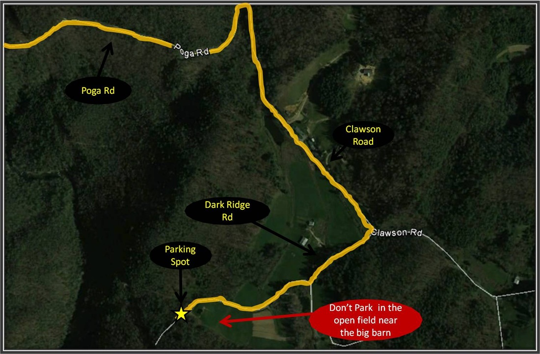
Turn left as 321 splits from 19 in Hampton near Pizza Plus and Subway. Continue on 321, making a right where 321 heads in the direction of Boone. A little over 7 miles after turning right toward Boone, make another right onto Poga Road. Follow Poga Road for 3.6 miles and then make a right onto Clawson Road. Take a right onto Dark Ridge Road after traveling Clawson Road for a half-mile. Dark Ridge Road turns to gravel as the road leads toward a big barn. The gravel road is mostly well maintained but there is a pretty rough bump along the way that may be better suited for a vehicle with some off-road potential, although a Honda Accord did manage the obstacle. Straight ahead and close to the barn is a forestry gate that will most likely be closed. The trailhead for the path leading to the falls is on the right across from the barn before the forestry gate. A tree marked with yellow and red spray paint marks the starting point. Do not park next to the barn or up in the pasture. This is private property and there is a strong risk of getting towed. The best place to park is between the spray-painted tree and gate, without blocking tthru traffic onto the forestry road. There is another waterfall not far upriver from the dominant falls, which was known as Twisting Falls first but over time people have come to call Compression Falls, Twisting Falls as well. Driving directions to Twisting Falls using Google Maps is linked here. |
Elk River Falls to Jones Falls
Distance: approximately 4 miles round trip
Some of the hikes I talk about on this website weave between Tennessee and North Carolina. Many of the hikes here in Northeast Tennessee exist near the borders with other states, esp. North Carolina. The Appalachian Trail follows the border between the two states pretty tightly after leaving the Smokies and before the AT cuts back into Tennessee near the community of Elk Park, NC. Elk River Falls is located in North Carolina near the border with Tennessee in Avery County near the community of Elk Park. The Falls are beautiful and are easily accessible. The journey to the falls from the parking area for the falls could hardly be considered a hike with the falls being about the distance from walking from the Sam’s Club parking lot to Barnes & Noble by taking the steps here in Johnson City. Elk River Falls is well worth seeing on its own but if you were hoping to spread your legs out a bit for a hike, there is another beautiful waterfall on the other side of the border in Tennessee, situated just off of the AT that is accessible from Elk River Falls. Jones Falls is located approximately two miles from Elk River Falls, or approximately four miles round trip. I got the information on distance from a couple of different online resources and I believe this hike is also described in Gregory Plumb’s book on Tennessee waterfalls. Just be aware I might be wrong on the approximate distance but the hike itself is of moderate difficulty. After heading down to take in the awesome splendor of Elk River Falls, follow the Forestry Road which is blocked off by a forestry gate at the parking area for the falls. The road is to the left of the trail leading down to Elk River Falls. The Forestry Road heads down the hill, paralleling the curve of the Elk River. Eventually the forestry road crosses the Elk River so it’s key to remember at no time during the trek will the Elk River need to be crossed. Right before the road meets the Elk River, the path cuts through an open field on the left heading into the tree line, following the riverbank with the Elk River on the right. The trail maneuvers back into the tree line as the Elk River bends to the right. From here the trail crosses a stream as it is about to merge with the Elk River. For the most part, it is possible to rock hop this stream without getting boots drenched. This is the only point that requires crossing a stream, with the exception of some minor run-offs. From here the trail heads up hill, initially it is fairly steep but the steepness lets up and soon the path links up with the Appalachian Trail. From here make a left onto the Appalachian Trail. From here the path is mostly reasonable uphill switchbacks with occasional steep moments. The cut-off trail for Jones Falls is on the left just as the trail makes a sharp and steep right. A wooden signs marks the turn for Jones Falls and a nearby water source. Blue Blazes also mark the path to Jones Falls from the AT, only 0.1 miles away. Jones Falls is a pretty impressive waterfall, esp. when Jones Branch has got plenty of water. The way back is the way you came. Further Online Resources: Appalachian Treks Hiking Bill (Current as of Spring 2013) |
Elk River Falls
Jones Falls
|
|
Directions:
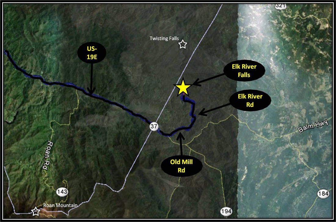
From ETSU, take a right onto University Parkway. From University Parkway, make a right onto South Roan St. Follow South Roan St. until making a left onto Okolona Road, also known as TN-359. Follow TN-359 until making a right onto TN-361. Follow TN-361 until turning right onto US-19E. Follow US-19E just past the North Carolina state line, making a left onto Old Mill Road in the community of Elk Park. From Old Mill Road turn left onto Elk River Road. Stay on Elk River Road as it eventually ends at the parking for Elk River Falls. From Elk Park the way to Elk River Falls is well marked with signs pointing the right way. The journey to Elk River Falls from ETSU is approximately 35 miles.
Driving directions to Elk River Falls using Google Maps is linked here. |
