Rocky Fork
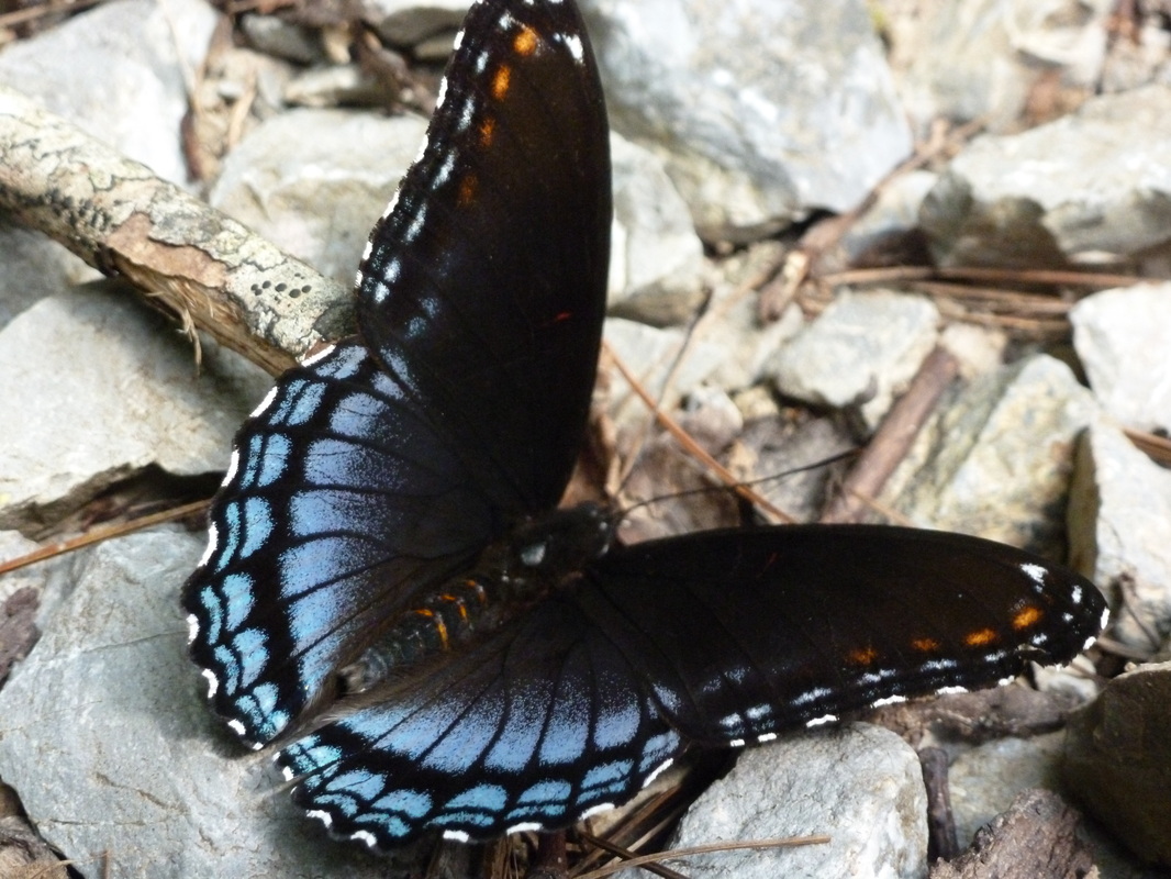 Flutterby on the way to the Hidden Lake
The Rocky Fork Area is currently in the process of great change in how it is understood culturally. It will still be the same land, most of it still owned by the Forestry Service but a portion will also become Tennessee's newest state park. Appalachian Treks, RATTreks, and others have good information on Lower Higgins Creek Trail, including photos and details on other nearby falls and cascades. Rocky Fork is developing and a formalized trail system is also developing. However there are many trails and forestry roads within the Rocky Fork, I highly recommend reading Hiking Bill and RATTreks on this area in particular.
The trails described below are: Lower Higgins Creek Trail to the Falls, Lower Higgins Creek Trail to Camp Birchfield Lake, Hidden Lake Trail, White House Cliffs Trail, Devil's Fork Gap to Sugarloaf Gap on the AT, and Devil's Fork Gap to Flint Mountain Shelter on the AT.
The trails described below are: Lower Higgins Creek Trail to the Falls, Lower Higgins Creek Trail to Camp Birchfield Lake, Hidden Lake Trail, White House Cliffs Trail, Devil's Fork Gap to Sugarloaf Gap on the AT, and Devil's Fork Gap to Flint Mountain Shelter on the AT.
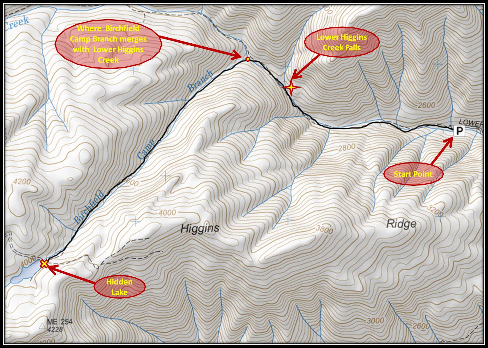
Lower Higgins Creek Trail to the falls
Distance: Approximately 2 miles Round Trip
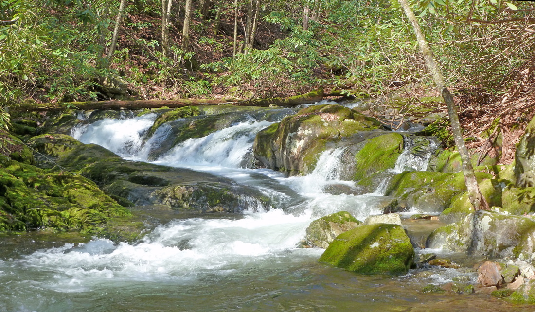
At a short round trip distance of two miles mostly along an old forestry road, the trek to Lower Higgins Creek Falls is one of the more accessible waterfall hikes in the area. Despite the accessibility of the hike, Lower Higgins Creek Falls is still less known than many of the other popular falls in the region. This is unfortunate for two reasons, one being the falls and the other being this trail is a good hike for those who appreciate wildflowers. Pictured below are some of the wildflowers like trillium and pale touch-me-nots that grow along the way. The hike to the falls is fairly straight forward following an old forestry road from the parking area to the falls approximately a mile further up the mountain without any turns except for the right turn onto a rough trail leading down to the base of the falls. A bridge inspiring no one's confidence marks the start of this trek. The trail is mostly a reasonable uphill, but just before reaching the right turn leading down to the falls, the path gets pretty steep for a little bit before leveling out. As the path levels out, Lower Higgins Creek Falls is easily observable through the trees and rhododendrons. The path leading down to the falls resembles more of a run-off and is fairly treacherous. Footing can be slick. The way back up on this makeshift path to the main trail is even less fun than the way down but worth it for the view of the falls. This is a there and back again hike. Further Online Resources: Appalachian Treks Hiking Bill: Lower Higgins Creek Falls Hiking Bill: Rocky Ford RATtreks.com (Current as of Winter 2014) |
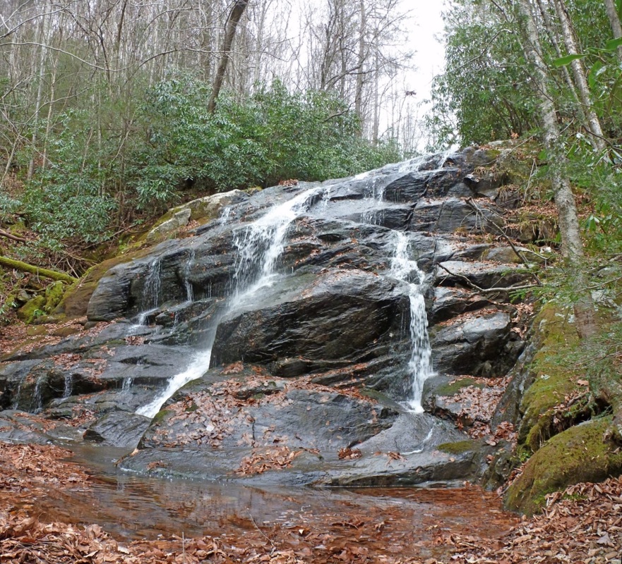
Lower Higgins Creek Falls during Autumn
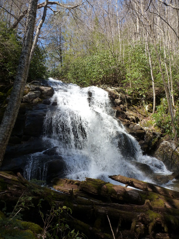
Lower Higgins Creek Falls during Early Spring
|

|
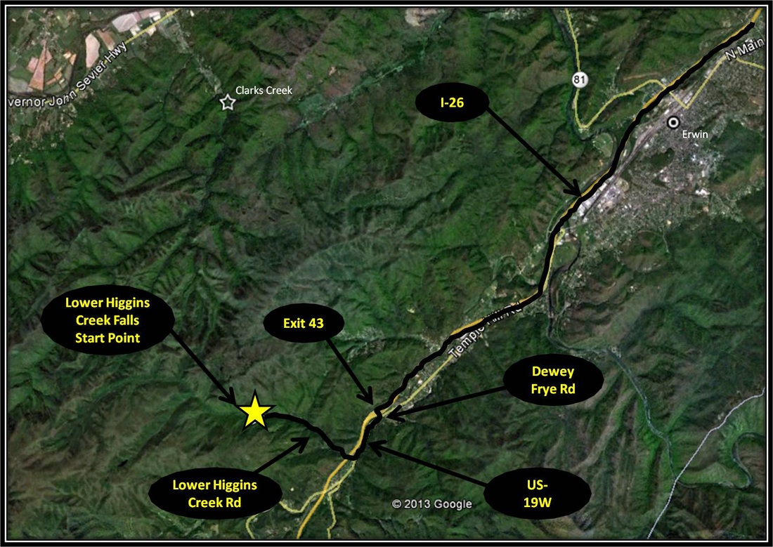
Driving Directions:
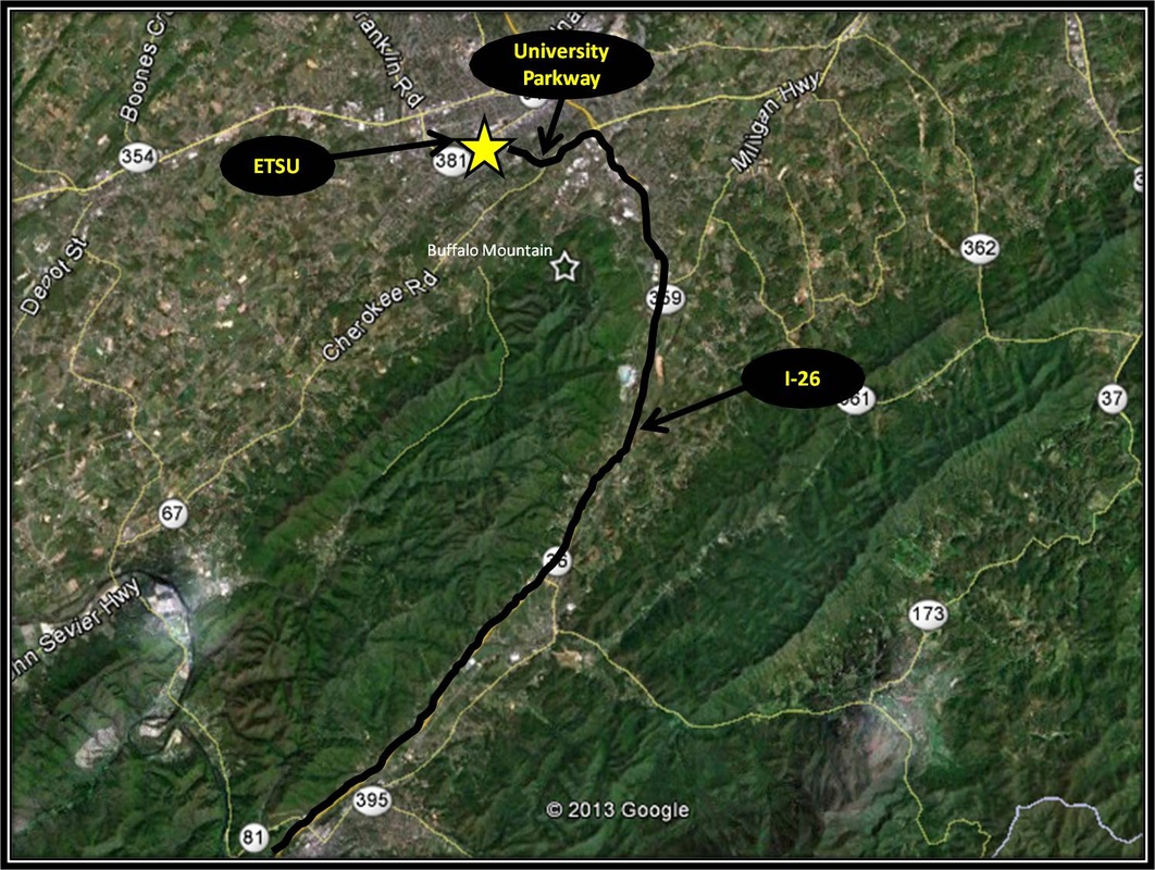
From ETSU, take University Parkway to I-26. Turn right onto I-26 headed toward Erwin and Asheville. Take Exit 43 also known as the Temple Hill Road Exit. Turn left onto Dewey Frye Rd and then right onto US-19W. Make the first right onto Lower Higgins Creek Rd not long after turning right onto US-19W. Follow Lower Higgins Creek Rd as it narrows following the creek past several properties eventually coming to an end at a small cut-off for parking and a chain crossing the road with a no trespassing sign. There is not much room for parking but to the left of the parking area is the bridge that inspires confidence in no one and the start of the hike.
Directions to the Lower Higgins Creek Waterfall using Google Maps is linked here. |
Lower Higgins Creek Trail to hidden lake
|
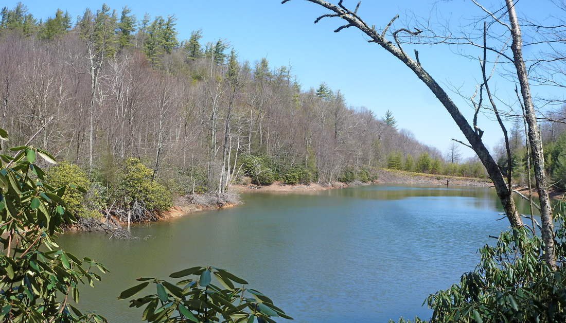
Hidden Lake is Hidden Lake no more.....
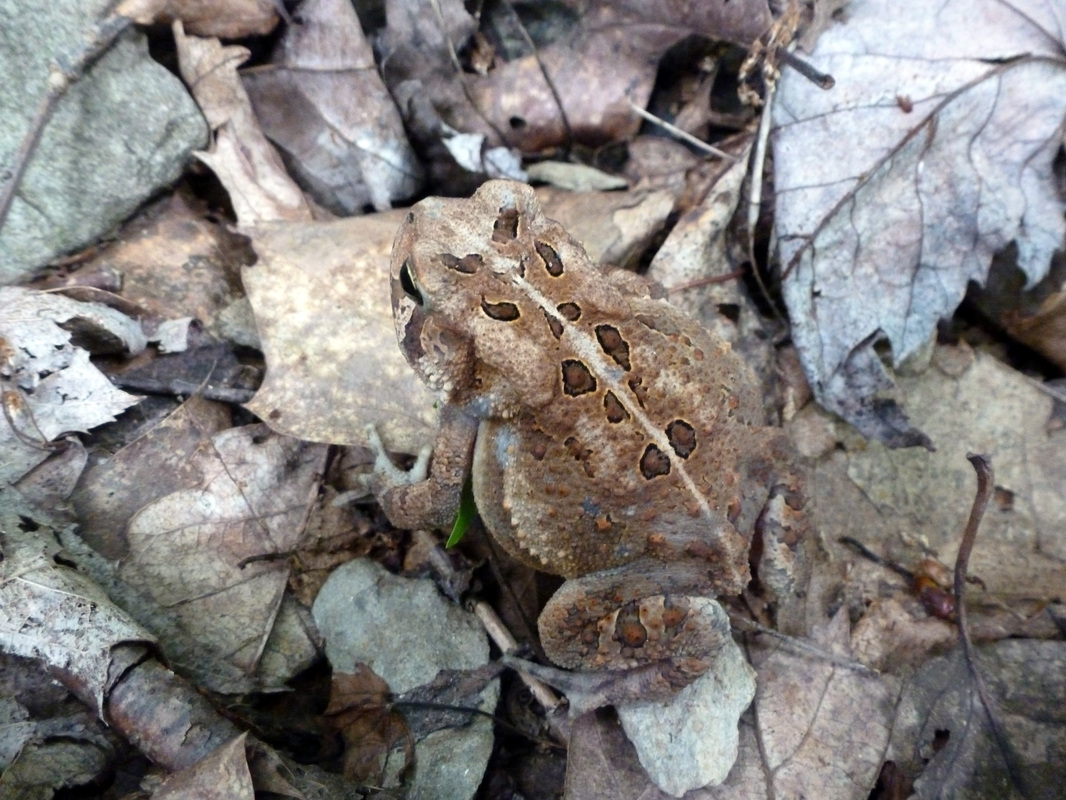
Distance: Approximately 4.5 miles total, 2.25 miles one-way Sometimes referred to as Hidden Lake, Camp Birchfield Lake is located beneath Frozen Knob in a saddle along Higgins Ridge in the mysterious Rocky Fork. The lake was originally constructed as a location for fire-fighting forces to pick-up water from above. In the meantime, Camp Birchfield Lake has become a beautiful landscape and a popular breeding ground for frogs, as well as a popular frog-leg diner for black bears. There is more than one way to get to Hidden Lake, the quickest route starts from Lower Higgins Creek Trail. From the the bridge that inspires no confidence the route follows Lower Higgins Creek Trail for about a mile before splitting onto a primitive trail following Camp Birchfield Branch for a little over a mile before reaching Hidden Lake about 2.25 miles from the start of the hike. Starting from the bridge that inspires no confidence, Lower Higgins Creek Trail parallels Lower Higgins Creek. After an initial climb, the trail levels out and opens up a little before passing by a blue forestry gate. For the most part Lower Higgins Creek Trail is mostly reasonable uphill at the beginning, but gets steep for a mean minute just before reaching the steep side-trail leading down to Lower Higgins Creek Falls. Not far past the Falls, Lower Higgins Creek Trail crosses Lower Higgins Creek for the first time. This crossing might be hard to accomplish without getting wet shoes when the water is running high. Near where the trail crosses the creek, a fallen tree has been laid over the creek which might be helpful for the cross. About a 100 paces past the first creek-crossing, as Lower Higgins Creek Trail begins to veer right, a vanishing path forks left toward Lower Higgins Creek. Another creek known as Camp Birchfield Branch merges into Lower Higgins Creek just a little further uphill and within eyesight. The trail picks up on the other side of Lower Higgins Creek for the second creek crossing of the hike. Like the first crossing, this one might also be tough to accomplish without getting shoes and socks a bit soaked. From here the primitive trail follows Camp Birchfield Branch crossing the creek about seven (7) times on the way to the lake. Most of these creek-crosses can be accomplished without getting wet through rock-hopping. In some places the path merges and becomes a part of a side-stream looking to merge with Camp Birchfield Branch. For the most part, the primitive path is well-defined and was at one time a forestry road. Rhododendrons and other flora are encroaching on the route and the creek has washed away the road in some places, but humans and other animals have kept the way to the lake navigable. The route is steep as it parallels Camp Birchfield Branch, leveling out some at creek crossings. Near the lake's destination, the path levels out some and passes by a skeleton of an old logging truck slowly being reclaimed by the forest, a reminder of the Rocky Fork's logging history. Past the truck, Camp Birchfield Branch is crossed one more time before reaching the lake. Past the crossing, the trail gets steep once again for a brief stint climbing through what feels like a tunnel formed of Great Rhododendrons. From out of the Rhododendron tunnel, the trail spits out onto Camp Birchfield Lake. After exploring the lake, the way back is the way you came. In total making for an approximate 4.5 total miles hiked. Neither Lower Higgins Creek trail or Camp Birchfield Branch's primitive trail are marked as Rocky Fork is amongst the newest additions to Cherokee National Forest. Despite the lack of markings, the trails are well worn and are not hard to navigate. It is key to keep an eye out for where Camp Birchfield Branch merges with Lower Higgins Creek. The hike is ony 2.25 miles one-way to the lake but much of it is steep uphill and often on rocky footing. There are many creek-crossings on the way but most are no worries, with maybe the exception of the two points where Lower Higgins Creek is crossed. Given all this, the quick way to Hidden Lake is of moderate difficulty. Further Online Resources: Hiking Bill: Rocky Ford RATTreks: Lower Higgins Creek to Camp Birchfield Falls Johnson City Press: Springtime at Rocky Fork Possibly Helpful Map (Current as of Winter 2014) |
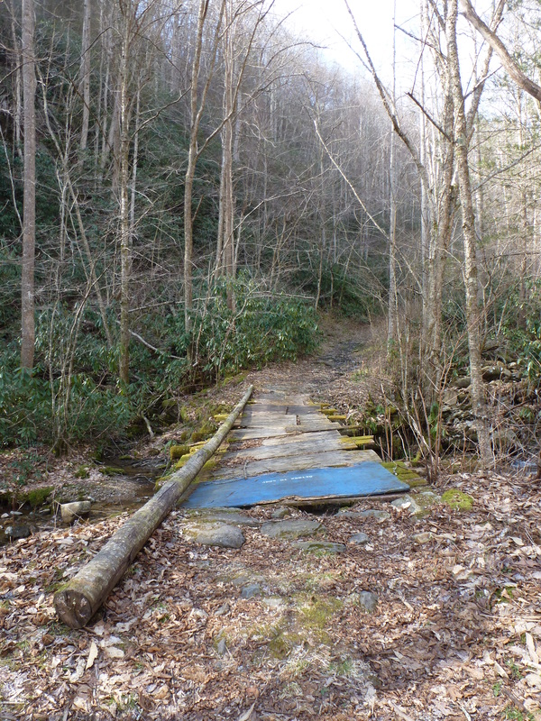
The Bridge that Inspires No Confidence
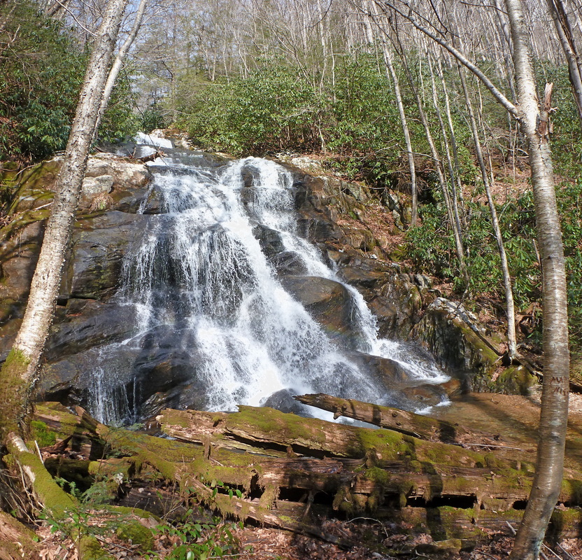
Lower Higgins Creek Falls
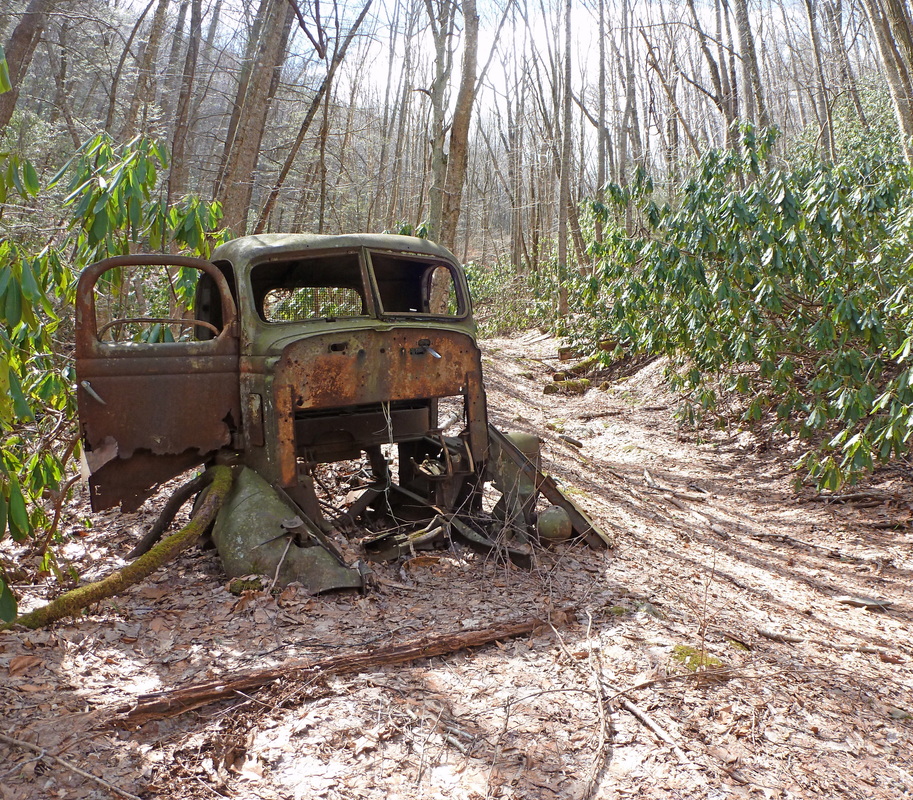
Old Logging Truck along the Primitive Path paralleling Camp Birchfield Branch
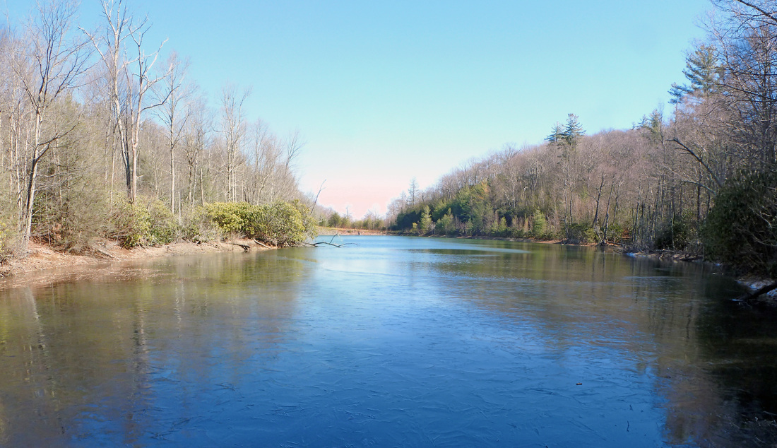
Camp Birchfield Lake aka Hidden Lake
|


|
Driving Directions:
From ETSU, take University Parkway to I-26. Turn right onto I-26 headed toward Erwin and Asheville. Take Exit 43 also known as the Temple Hill Road Exit. Turn left onto Dewey Frye Rd and then right onto US-19W. Make the first right onto Lower Higgins Creek Rd not long after turning right onto US-19W. Follow Lower Higgins Creek Rd as it narrows following the creek past several properties eventually coming to an end at a small cut-off for parking and a chain crossing the road with a no trespassing sign. There is not much room for parking, a few vehicles at most.
Directions to the Lower Higgins Creek Waterfall using Google Maps is linked here. |
Hidden lake trail
|
Hidden Lake has drained and is currently a depression...
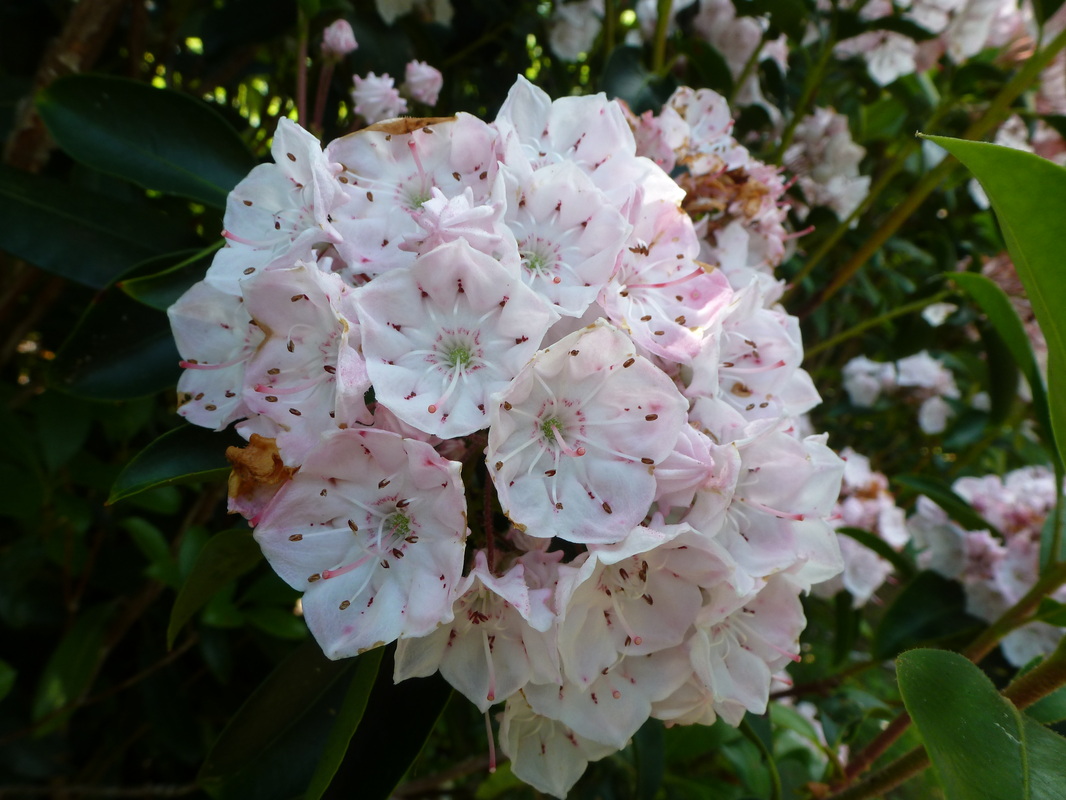
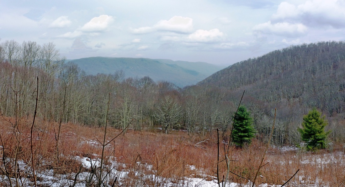
Distance: Approximately 11.6 miles round trip Beginning from the main blue gate off of Rocky Fork Road, Hidden Lake Trail parallels the Rocky Fork before making the long climb over the Lower Higgins Ridge, eventually reaching Camp Birchfield Lake, aka the Hidden Lake, approximately 5.8 miles away. At first, Hidden lake Trail is mostly level as the path follows the lush Rocky Fork. The trail keeps to the right of the well-reputed fly-fishing creek, with make-shift side-trails cutting away to possible fishing spots and mesmerizing land features like Triple Falls. As the path begins to curve away from the Rocky Fork, the trail splits. Take the trail leading right headed up the hillside. Be aware the Rocky Fork is developing and the trails are not yet clearly marked. The path cutting away to left is the Flint Creek Trail. After the 1st right turn, Hidden Lake Trail becomes a steep, steady climb before leveling out for a short distance, reaching where the Headwaters Trail and Hidden Lake Trail diverge at a level spot known as White Oak Flats. Turn right headed up the hillside to continue on Hidden Lake Trail. After the 2nd right turn, Hidden Lake Trail ascends up the hillside, sometimes at a callously steep incline. Wildflower species like: Trailing Arbutus, Galax, Mountain Laurel, Great Rhododendron, Indian Cucumber Root, St Johns Wort, and Flame Azalea bloom on the trail's rocky shoulders. Eventually, the trail quits curving around the mountainside and cuts up and over the ridge. From here, Hidden Lake Trail skirts the ridge slightly declining to another intersection where the High Country Trail links up with the Hidden Lake Trail. Turn right, staying on Hidden Lake Trail. After the 3rd right turn, Hidden Lake Trail climbs again for a tiny bit before leveling out and descending toward another intersection of paths where Lower Higgins Creek Trail meets up with the Hidden Lake Trail. Lower Higgins Creek Trail links up to the trail from the left. Stay right to continue on Hidden Lake Trail. Almost immediately after the 4th right turn, the trail reaches another fork. This fork is the loop that leads down to and around Camp Birchfield Lake, so heading left or right both leads around the serene Hidden Lake. A TWRA 'No Camping' Sign has been placed on a tree where the loop around the lake forks. As a there and back again hike, the way back is the way you came making for a hike approximately 11.6 miles total. Distance to the lake is approximate and based on information provided by the Rocky Fork Primary Trail Map. Hiking Bill describes this hike as being approximately 11 miles. Both sources are linked below. Besides being unmarked by blaze or trail sign, old and vanishing forestry roads also intersect with the route. These forestry roads are becoming overgrown but still have some potential to confuse the way, so remember to stay observant. Otherwise, at the four key intersections remember to turn right on the way to the lake and turn left on the way back from the lake. Hidden Lake Trail is a rigorous dayhike with some mean uphill. On the spurs leading up the hillside between the 1st and 3rd turns, the sun can bake the hydration right out of you. Additionally, the Rocky Fork is prime Black Bear habitat. There are no stream crossings to be concerned with but the trail can get a bit soft when the weather is wet. Given the distance, much of it uphill, and lack of trail-markings, Hidden Lake Trail is at a level of difficult. Further Online Resources: Rocky Fork Trail Map Hiking Bill: Rocky Fork to Birchfield Camp Lake Greeneville Sun Article by Lauren Henry |
Triple Falls on the Rocky Fork
A Fellow Traveler along Hidden Lake Traveler
Mountain Laurels blooming along Hidden Lake Trail
Growing Up in Camp Birchfield Lake
Camp Birchfield Lake aka the Hidden Lake
|

|
driving directions:
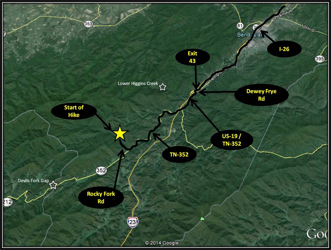
From ETSU, turn right onto University Parkway. From University Parkway, turn right onto I-26 headed east. Stay on I-26 for about 19.5 miles. Then take Exit 43, the Temple Hill Exit and turn left onto Dewey Frye Road.
From Dewey Frye Rd, turn right onto US-19 / TN-352 headed toward Flag Pond. Stay right on TN-352, as US-19 splits left toward Spivey Gap. Travel TN-352 for another 4.8 miles and make a right onto Rocky Fork Road. Travel Rocky Fork Rd for about a mile. The Blue Gate where the hike begins will be on the left. There is pretty limited parking space at the gate. There is some pull-off parking along Rocky Fork Rd before the gate is reached. Driving Directions to Rocky Fork using Google Maps is linked here. |
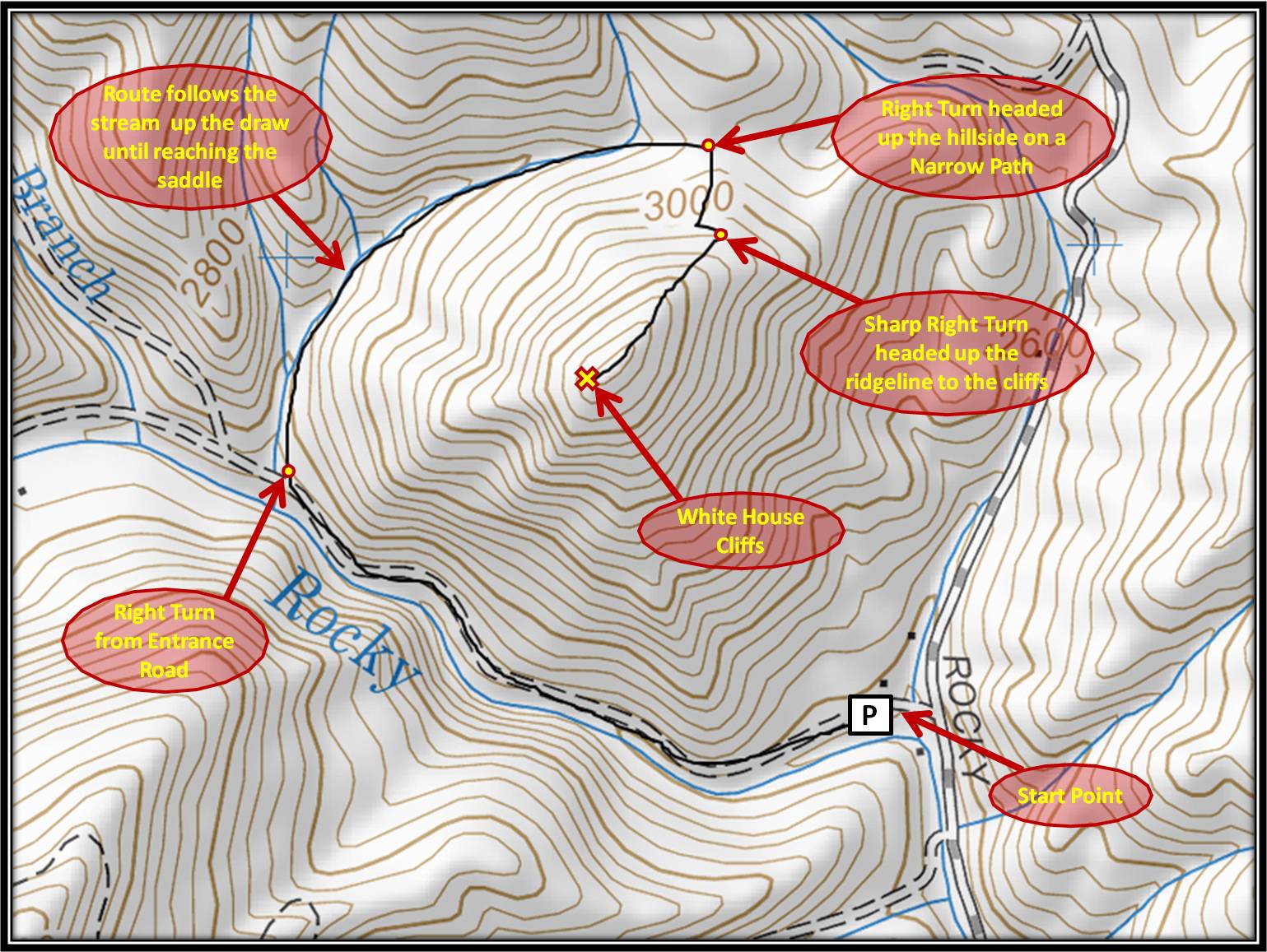
White House Cliffs Trail
|
Distance: Approximately 2.7 miles round trip
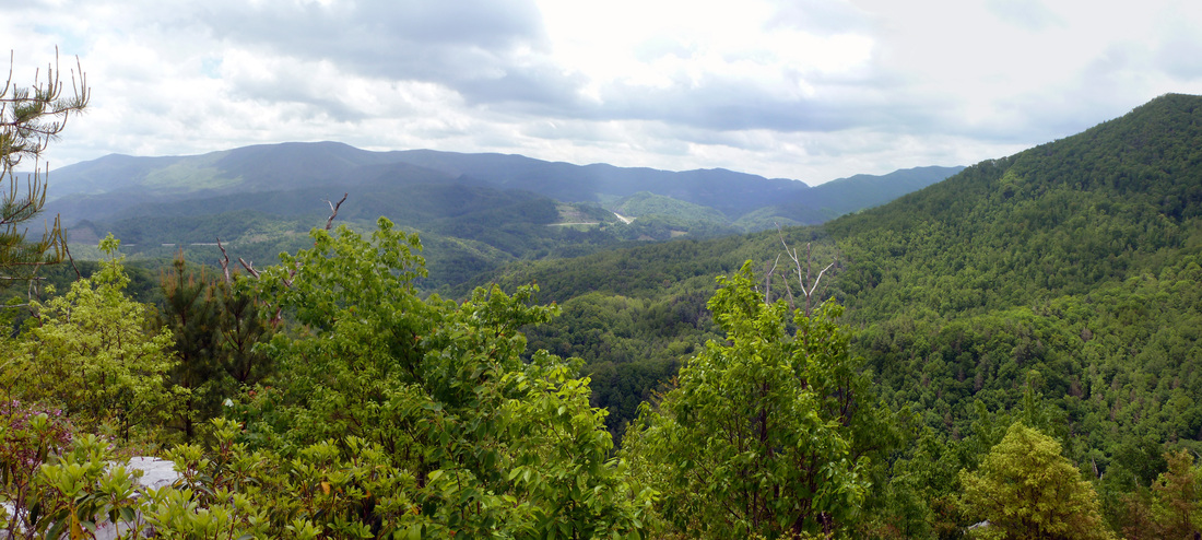
The Rocky Fork is home to two reputed panoramas, the nearby White House Cliffs and the distant Buzzard Rock. Among the two, there are more than a few whispers here locally about the remote Buzzard Rock being the perch with the best civilization-free views in the region. However, the hike to Buzzard Rock originating from the Rocky Fork is long for a day hike at approximately seven strenuous miles one-way, 14 miles round trip. A shorter route to Buzzard Rock actually originates from Horse Creek. The hike to White House Cliffs is much shorter in distance at about 2.7 miles round trip, than the trek to Buzzard Rock but the scenery the cliffs offer are no less incredible, esp looking southwest into the heart of the Rocky Fork from Flint Mountain to the Higgins Ridge. Starting from the small parking area, follow the entrance road as the trail parallels the Rocky Fork. Showy Orchis, Dwarf Crested Iris, Woodland Phlox, Mountain Stone-Crop, and Ragwort are among the many species of wildflower that bloom along the entrance road. Views of Triple Falls are also along the route. After hiking about half a mile on the entrance road, take the trail splitting to the right, cutting through the forest following a small stream up a draw in the mountain. A narrow wooden pole marks where the trail splits from the entrance road. You will know you missed the right turn if you come to the split between Flint Creek Trail and the Headwaters Trail. As the trail leads up the draw following the stream there are about four different points where the stream is crossed. At a couple of these crossings, the trail and the stream have merged. The stream is small and almost non-existent during dryer moments, but still expect this portion to be mucky and popular with salamanders. The trail follows the stream for about half a mile before leveling out onto a brief saddle. Just before the path appears to descend, a narrow deer trail cuts right and up the hillside through dense forest. Orange Ribbon has been tied around branches and saplings to mark the trail. Be careful as the trail can be easy to lose and the ribbons hard to see. After briefly heading straight up the hillside, the trail makes a sharp left, switching back onto the ridgeline. Several forestry signs and markers have been placed near where the trail comes up onto the ridge. From here the route makes a sharp right, steeply headed up the ridge toward the cliffs. A helpful reminder to remember this spot is key, as the trail back down the hillside is very tough to find otherwise. The trail so far has hinted at steep but finally gets serious during this last brief stretch. Cherokee National Forest property signs, bearing tree signs, trees spray-painted with a red ring mark the route, along with a couple of trees marked with three prominent slash marks spray-painted red. Along the steep ridge, Pink Lady Slipper Orchids, American Lily of the Vally, and Catawba Rhododendron thrive. Near the top, the trail gets more difficult to navigate as the path weaves through the rocky hilltop and encroaching flora like Wild Blueberry, Clammy Locust, and Mountain Laurels before reaching the open panoramas offered by White House Cliffs. As a there and back again hike, the way back is the way you came. The hike to White House Cliff is a short hike at approximately 1.35 miles one-way, 2.7 miles round trip, with some steep stretches. Despite the short distance, the way is not traditionally marked and the path can be easy to lose. Do to the tricky navigation and steepness, this hike is rated as moderate. Further Online Resources: Rocky Fork Trail Map Possibly Helpful Map Cherokee WMA - Rocky Fork Unit (excellent natural data esp for birders, site was uploaded before the Rocky Fork Tract was purchased by the USFS) Tenn State Parks: Rocky Fork State Park Facebook.com: Rocky Fork State Park Timeline Post of guided tour up to White House Cliffs Overlook (Current as of Spring 2014) |
View from White House Cliffs
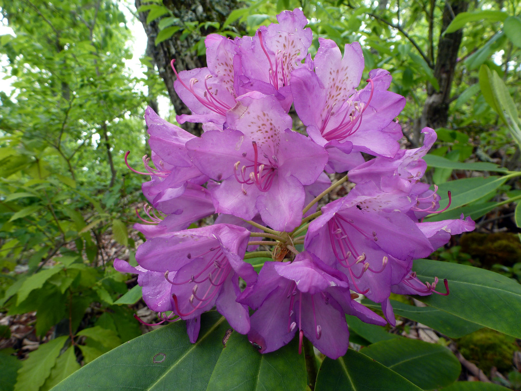
Catawba Rhododendron blooming near White House Cliffs
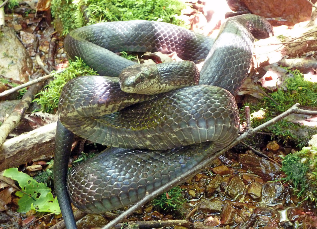
Rat Snake along the route to White House Cliffs
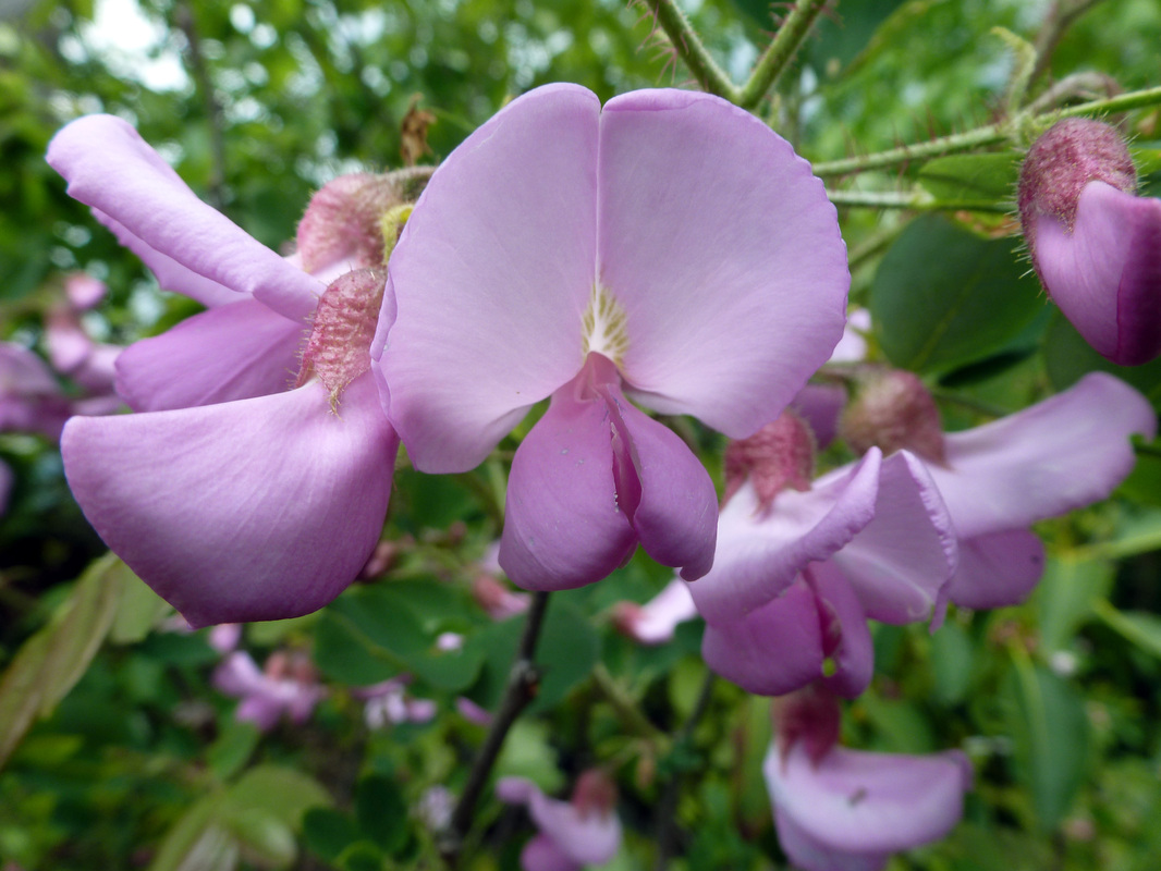
Clammy Locust blooming near White House Cliffs
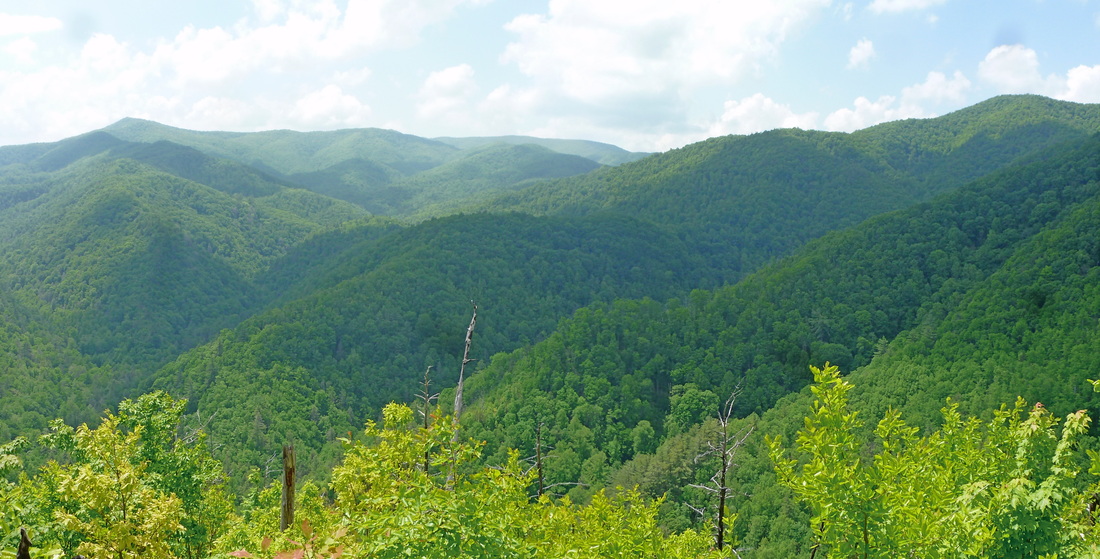
View into the Rocky Fork from White House Cliffs
|

|
driving directions:
From ETSU, turn right onto University Parkway. From University Parkway, turn right onto I-26 headed east. Stay on I-26 for about 19.5 miles. Then take Exit 43, the Temple Hill Exit and turn left onto Dewey Frye Road.
From Dewey Frye Rd, turn right onto US-19 / TN-352 headed toward Flag Pond. Stay right on TN-352, as US-19 splits left toward Spivey Gap. Travel TN-352 for another 4.8 miles and make a right onto Rocky Fork Road. Travel Rocky Fork Rd for about a mile. The Blue Gate where the hike begins will be on the left. There is pretty limited parking space at the gate. There is some pull-off parking along Rocky Fork Rd before the gate is reached. Driving Directions to Rocky Fork using Google Maps is linked here. |
Devil's Fork Gap to Sugarloaf Gap on the AT
|
Distance: 3.6 miles round trip
As the AT heads north from Devils Fork Gap for 1.8 miles up to Sugarloaf Gap, epic displays of spring wildflowers bloom along the route. Among the spring wildflowers to be found are waves upon waves of Trout Lilies. Red Trillium, Painted Trillium, Speckled Wood Lily, Dwarf Larkspur, Wood Anemone, Dutchman Breeches, Squirrel Corn, and many other species also bloom along the route. In addition to the great wildflower viewing, the AT crosses by a waterfall along the Sugarloaf Branch on the way to a nice mountain vista from a clearing at Sugarloaf Gap. From Devils Fork Gap headed northbound, the hike begins by climbing a small staircase over a barb-wire fence and briefly traveling through a pasture before returning back into forest. Not far past the pasture the AT switchbacks down to Rector Laurel Rd. Immediately after crossing Rector Laurel Rd, Laurel Creek is crossed by bridge. Shortly after crossing the road, the AT adjoins another path. Branches have been laid at the intersection to help guide the route as it curves right. White Blazes mark the way. Shortly past the intersection, the AT crosses a dirt road and heads up through a rhododendron thicket before ascending down to an easy stream crossing. Past the stream crossing, a steep set of stairs are climbed. Just past the steps, the AT journeys by a small, fenced cemetery with two tombstones. Not far past the small cemetery, the AT crosses the Sugarloaf Branch and ascends toward the gap by switchback following the stream. The next easy stream-crossing occurs below a small waterfall on Sugarloaf Branch and the one after occurs above the top of the small fall. From here the AT climbs some more before leveling out on a saddle along the ridge for a brief moment. The AT then journeys by a boulder garden before leveling out and journeying through a young forest. The vista offered from an old apple orchard along the AT is just moments away after passing through the young forest. The view is the crescendo and turn-around point of this short hike. As a there and back again hike, the way back is the way you came. At 3.6 miles total, this hike is of easy to moderate difficulty do to the amount and intensity of the uphill. Navigation is mostly straightforward with the White Blaze marking the way. There are about five points where a stream is crossed. All are easily accomplished. Further Online Resources: CMC Hike Data: Sam's Gap to Devil's Fork Gap Hiking Trails of Unicoi County (Current as of Spring 2014) |
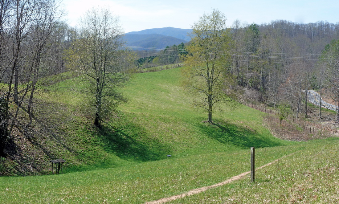
View from Pasture at the Start of the Hike
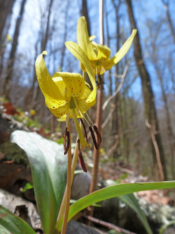
Trout Lilies bloom like Spring Beauties and Violets along the Way
View from Sugarloaf Gap along the AT
|

|
Driving directions:
From ETSU turn right onto University Parkway. From University Parkway merge right onto I-26 headed south toward Erwin and Asheville. Stay on I-26 for approximately 20 miles before taking Exit 43 toward Temple Hill Road. After Exit 43, turn left onto Dewey Fry Rd / US-19, and then turn right at the stop sign onto US-19 / TN-352. Keep right on TN-352 when US-19 splits off to the left. Stay on TN-352 for about 5 miles, before making another right staying on TN-352. Continue on TN-352 for about another four miles until reaching the state line with North Carolina and the road becomes NC-212. Right after the state line is crossed, parking for the AT and the start of the hike is on the left.
Directions to Devil's Fork Gap using Google Maps is linked here. |
devil's fork gap to flint mountain shelter on the AT
|
Distance: 5.4 miles round trip
Flint Mountain Shelter is located 2.7 miles from Devil's Fork Gap headed southbound along the AT. This is a there and back again hike making for a round trip distance of 5.4 miles. The hike is mostly level with stints of uphill and downhill on the way to and from the shelter. There are a couple of steeper sections but these sections are very short in length. All of the trek is through mixed forest and at times dense Great Rhododendron thickets. Wildflowers like Mountain Laurel, Galax, St Johns Wort, and Gentian bloom along the route when the season is right. The AT through this section is well-marked with the white blaze making navigation easy. There are a few streams but they are small and can be crossed without getting shoes or socks wet. This hike is an easy to moderate difficulty level do to the 5.4 miles total distance and reasonable uphill grades. Further Online Resources: Carolina Mountain Club Carolina Mountain Club: 90 in 90 Hiking Bill (Current as of Winter 2014) |
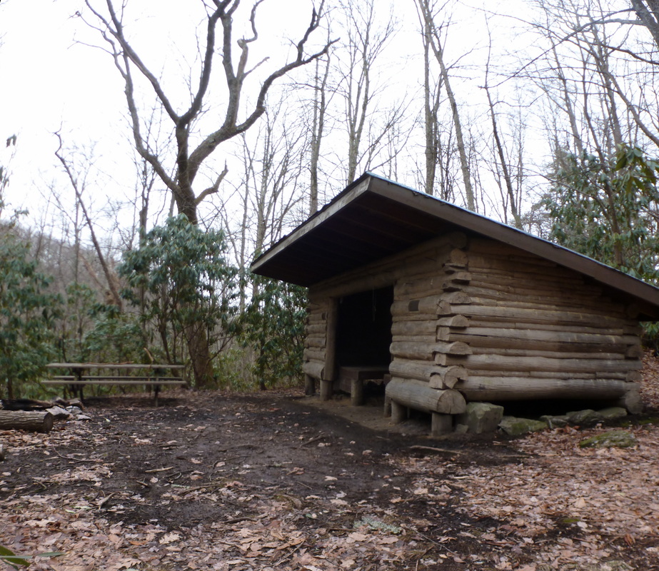
Flint Mountain Shelter was built in 1988 by the Carolina Mountain Club
|

|
Driving directions:
From ETSU turn right onto University Parkway. From University Parkway merge right onto I-26 headed south toward Erwin and Asheville. Stay on I-26 for approximately 20 miles before taking Exit 43 toward Temple Hill Road. After Exit 43, turn left onto Dewey Fry Rd / US-19, and then turn right at the stop sign onto US-19 / TN-352. Keep right on TN-352 when US-19 splits off to the left. Stay on TN-352 for about 5 miles, before making another right staying on TN-352. Continue on TN-352 for about another four miles until reaching the state line with North Carolina and the road becomes NC-212. Right after the state line is crossed, parking for the AT and the start of the hike is on the left.
Directions to Devil's Fork Gap using Google Maps is linked here. |
